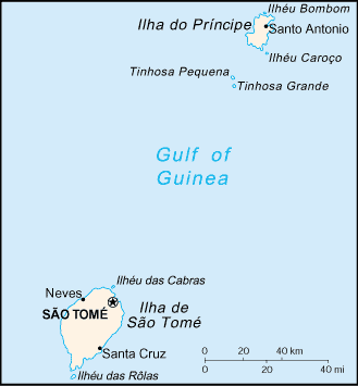
Ilhéu Caroço

Ilhéu Caroço
Ilhéu Caroço
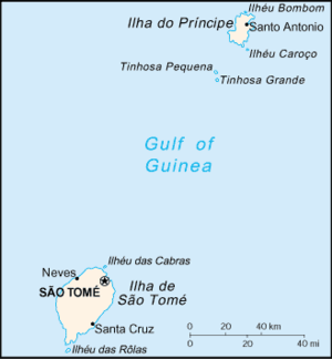
Mapa de Santo Tomé y Príncipe con Ilhéu Caroço al sureste de la isla de Príncipe.
Población: deshabitada
Elevación: N/A
Coordenadas: 1 N
7 O
Localización: sureste de la isla Príncipe, Santo Tomé y Príncipe
Tipo: Estratovolcánica

Ilhéu Caroço es un islote que pertenece al país de Santo Tomé y Príncipe, en el Golfo de Guinea. El islote se encuenta al sureste de la costa de la isla de Príncipe, a 1º N 7º O. No hay población permanente.


Wikimedia foundation. 2010.

Игры ⚽ Нужен реферат?

Mira otros diccionarios:

  • Ilhéu Caroço — is an island in the Gulf of Guinea and is one of the smaller islands of São Tomé and Príncipe. The islet is located southeast of the island of Príncipe …   Wikipedia

  • Ilhéu Caroço — Vorlage:Infobox Insel/Wartung/Bild fehltVorlage:Infobox Insel/Wartung/Höhe fehlt Ilhéu Caroço Gewässer Golf von Guinea Geographische Lage …   Deutsch Wikipedia

  • List of São Tomé and Príncipe-related topics — This is a partial list of topics related to São Tomé and Príncipe. Geography * Extreme points of São Tomé and Príncipe * List of volcanoes in São Tomé and Príncipe Landforms Islands * Ilheu Bom Bom * Ilhéu das Cabras * Ilhéu Caroço * Ilhéu das… …   Wikipedia

  • Geografía de Santo Tomé y Príncipe — Santo Tomé y Príncipe se encuentra situado en el Atlántico, al sur de la isla de Fernando Poo, (Guinea Ecuatorial) en el Golfo de Guinea. Dista 300 km al noroeste de la costa de Gabón, y es el país africano de menor superficie. El país está… …   Wikipedia Español

  • Liste der Inseln von São Tomé und Príncipe — Karte mit den wichtigsten Inseln von São Tomé und Príncipe Die Liste der Inseln von São Tomé und Príncipe enthält die Inseln, aus denen der Staat São Tomé und Príncipe im Atlantik vor der Küste Zentralafrikas besteht. Ilhéu Bom Bom Ilhéu das… …   Deutsch Wikipedia

  • Pagué — Príncipe Basisdaten Hauptstadt: Santo António Fläche: 142 km² …   Deutsch Wikipedia

  • Principe — Príncipe Basisdaten Hauptstadt: Santo António Fläche: 142 km² …   Deutsch Wikipedia

  • Príncipe — Infobox STP provinces capital=Santo António area=136 km² lowest=Atlantic Ocean centre=Santo António highest=Pico de Príncipe (948 m) population=around 5,000 density=about 36 totaldistricts=1 (Pagué) phone number=19x xxxx? inhabitants=Príncipean… …   Wikipedia

  • Cameroon line — Map of the Gulf of Guinea, showing the chain of islands formed by the Cameroon line of volcanoes. The Cameroon line is a 1,000 km (620 mi) chain of volcanoes.[1] It includes islands in the Gulf of Guinea and mountains that extend along… …   Wikipedia

  • Príncipe — Karte Gewässer Golf von Guinea G …   Deutsch Wikipedia

Compartir el artículo y extractos

Link directo
Do a right-click on the link above
and select “Copy Link”