Khanlar

Khanlar

Khanlar

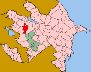
Localización de Khanlar resaltada con rojo en el mapa azerí.

Khanlar (Göygöl) (Azerí: Xanlar) es uno de los cincuenta y nueve rayones en los que subdivide políticamente la República de Azerbaiyán. La ciudad capital es la ciudad de Göygöl.

Contenido

Territorio y Población

Este rayón es poseedor una superficie de 1.380 kilómetros cuadrados, los cuales son el hogar de una población compuesta por unas 54.700 personas. Por ende, la densidad poblacional se eleva a la cifra de los 39,63 habitantes por cada kilómetro cuadrado de este rayón.

Economía

La región está dominada por la agricultura. Se producen vino, frutas y hortalizas y se practica la ganadería a menor escala.[1]

Transporte

A través del rayón pasa una autopista y una línea de ferrocarril de "Azərbaycan Dövlət Dəmir Yolu".[1] .

Referencias

  1. a b azerb.com Información del rayón.
Obtenido de "Khanlar"

Wikimedia foundation. 2010.

Игры ⚽ Нужен реферат?

Mira otros diccionarios:

  • Khanlar — DMS …   Deutsch Wikipedia

  • Khanlar Safaraliyev — (c.1878 – 19 September 1907) was an Azerbaijani oil field worker, labor organizer, and Moslem social democrat. In 1907, he helped lead a successful strike at the Baku oil fields. Subsequently, he was shot by an assassin, Jafar (a foreman in the… …   Wikipedia

  • Khanlar Mirza — whose royal title was Ehteshami ed Dowleh was commander of Nasser al Din Shah s forces in Bushehr during the Anglo Persian War. He was the seventeenth son of Abbas Mirza. Biography On 25 October, 1856 Persian forces re occupied the city of Herat …   Wikipedia

  • Goygol — Khanlar and Xanlar redirect here as former names for Goygol city and rayon; for the suburb of Baku, see Xanlar, Baku. Goygol, Göygöl or Goygöl may refer to:* Goygol (lake), a lake in Azerbaijan * Goygol (rayon), a rayon in Azerbaijan * Goygol… …   Wikipedia

  • Goygol (city) — For Xanlar (formerly Helenendorf) in the Bibi Eybat oil fields, see Xanlar, Baku. Infobox Settlement name =Goygol settlement type=City Municipality native name = pushpin pushpin mapsize =300 subdivision type = Country subdivision name =… …   Wikipedia

  • Goygol Rayon — For Xanlar in the Bibi Eybat oil fields, see Baku and Baku Oil Fields. Goygol ( az. Göygöl) is a rayon (district) in northwestern Azerbaijan. Formerly known as Khanlar, the region was renamed to Goygol , after the Goygol, the famous blue lake,… …   Wikipedia

  • Tovuz, Azerbaijan — Infobox Settlement official name =Tovuz native name = pushpin pushpin mapsize =300 subdivision type = Country subdivision name = flag|Azerbaijan subdivision type1 = Rayon subdivision name1 =Tovuz leader title = leader name = established title =… …   Wikipedia

  • Northern Artsakh — Ethnic map of the Northern Artsakh region (between Mrav Mountains and Kura River) in 1886 1890 with today s international borders and Nagorno Karabakh de facto controlled territory frontier with Azerbaijan. Northern Artsakh (Armenian: Հյուսիսային …   Wikipedia

  • Dashkasan Rayon — Dashkasan   Rayon   Map of Azerbaijan showing Dashkasan Rayon …   Wikipedia

  • Battle of Khushab — Infobox Military Conflict conflict=Battle of Khushab partof=Anglo Persian War caption= British Indian forces attacking at the Battle of Khushab date= 7 February 1857 place= Khushab District, modern Pakistan result=British victory… …   Wikipedia

Compartir el artículo y extractos

Link directo
Do a right-click on the link above
and select “Copy Link”