Mare Humboldtianum

Mare Humboldtianum
Mare Humboldtianum
Mhumboldtianum.jpg
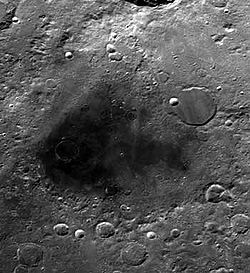
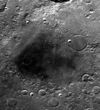
El Mare es la mancha oscura al centro de la imagen. La zona superior izquierda es ocupada por el cráter Bel'kovich.
Coordenadas 56.8° N, 81.5° E
Diámetro 273 km
Epónimo Mar de Alexander von Humboldt

Mare Humboldtianum (Latín para Mar de Humboldt) es un Mar Lunar, ubicado en el borde noreste de la cara visible de la Luna, que continúa hacia el lado oculto. Se encuentra hacia el este del Mare Frigoris.[1] Debido a su localización, su visibilidad es afectada por el movimiento de libración. La región posee una irregularidad gravitacional (mascon).[2]

Las coordenadas selenográficas del centro del mar son 56.8° N, 81.5° E, y tiene un diámetro de 273 km,[1] y un área de 35.475 km²,[3] similar a la superficie de Taiwan.[4] Sus anillos exteriores tienen un diámetro de unos 650 km.[2] El cráter Bel'kovich se encuentra en la porción oeste del mar.[1]

Fue nombrado en honor del explorador alemán Alexander von Humboldt, en reconocimiento a sus exploraciones en tierras desconocidas.[5]

Referencias

  1. a b c Lunar prospector: Atlas Lunar: Mare Humboldtianum (http://lunar.arc.nasa.gov/science/). Revisado el 19/12/2008.
  2. a b Wood, C.A. (2004) Impact Basin Database
  3. J. L..Whitford-Stark (1982) A Preliminary Analysis of Lunar Extra-Mare Basalts: Distribution, Compositions, Ages, Volumes, and Eruption Styles. The Moon and Planets 26, 323-338. (Tabla con áreas marinas lunares)
  4. La superficie de Taiwan es de 35.980km². CIA (Central Intelligence Agency. «CIA - The World Factbook». Consultado el 04/07/2008.
  5. The Moon: Humboldtianum Basin (http://the-moon.wikispaces.com)

Wikimedia foundation. 2010.

Игры ⚽ Поможем написать курсовую

Mira otros diccionarios:

  • Mare Humboldtianum — (NASA Aufnahme) Das Mare Humboldtianum (Lat. „Humboldt Meer“) ist ein Mondmeer des Erdmondes innerhalb des Humboldtianum Beckens östlich des Mare Frigoris. Es befindet sich auf den selenographischen Koordinaten 56,8° N, 81,5° E und weist einen… …   Deutsch Wikipedia

  • Mare Humboldtianum — is the dark patch at the center. The upper left is occupied by the walled plain Bel kovich. NASA image. Coordinates …   Wikipedia

  • Mare Humboldtianum — ( mer d Alexander von Humboldt, en Latin ) est une mare lunaire situé dans le bassin Humboldtianum, immédiatement à l Est de Mare Frigoris. Elle est située sur la bordure Nord Est du disque lunaire est chevauche la face visible et la face cachée… …   Wikipédia en Français

  • Mare Moscoviense — Coordinates …   Wikipedia

  • Mare Serenitatis — Photograph of Mare Serenitatis Coordinates …   Wikipedia

  • Mare Imbrium — A map showing the location of Mare Imbrium Coordinates …   Wikipedia

  • Mare Insularum — Mare Insularum, bordered by the craters Copernicus on the east, and Kepler on the west. Oceanus Procellarum joins the mare to the southwest. The northern edge of Mare Cognitum is visible at the bottom of the photo, and Fra Mauro is the grey patch …   Wikipedia

  • Mare Nectaris — Coordinates …   Wikipedia

  • Mare Vaporum — Mare Vaporum. The crater Manilius can be seen as the bright circular object to the right of the mare. To the south Rima Hyginus is visible as a light colored thin line. In the upper left hand side of the photo is the mountain range Montes… …   Wikipedia

  • Mare Orientale — Close up view of Mare Orientale Coordinates …   Wikipedia

Compartir el artículo y extractos

Link directo
Do a right-click on the link above
and select “Copy Link”