Veľký Kýr

Veľký Kýr
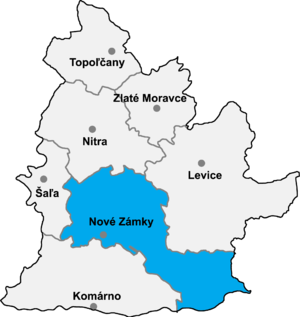
Nové Zámky Distrito en la región de Nitra.

Veľký Kýr (en húngaro: Nyitranagykér) es un pueblo y municipalidad en el Distrito de Nové Zámky en la Región de Nitra al sudoeste de Eslovaquia.

Contenido

Historia

Los primeros registros históricos de Veľký Kýr son de 1113.

Geografía

La municipalidad esta situada a una altitud de 130 metros y cubre un área de 23.638 km². Tiene una población de aproximadamente 3.095 personas.

Composición étnica

Húngaros - 64,29 %
Eslovacos - 35,27 %
Checos - 0,09 %
Otros - 0,35%

Composición religiosa

Católicos - 97,65 %
Ateos - 0,94 %
Evangélicos - 0,56 %
Ortodoxos - 0,03 %
Otros - 0.82 %


Equipamientos

El municipio cuenta con una biblioteca pública, un gimnasio, un campo de fútbol y una tienda de alquiler de DVD.

Enlaces externos

Coordenadas: 48°11′N 18°10′E / 48.183, 18.167


Wikimedia foundation. 2010.

Игры ⚽ Поможем сделать НИР

Mira otros diccionarios:

  • Veľký Kýr — Wappen Karte …   Deutsch Wikipedia

  • Veľký Kýr — (Village) Administration Pays  Slovaquie …   Wikipédia en Français

  • Veľký Kýr — Parish Church Veľký Kýr (Hungarian: Nyitranagykér) is a village and municipality in the Nové Zámky District in the Nitra Region of south west Slovakia. Contents …   Wikipedia

  • Liste der Städte und Gemeinden in der Slowakei/S-Ž — Übersicht S bis Ž Teil 1 A bis G Teil 2 H bis Ľ Teil 3 M bis R Teil 4 S bis Ž Übersicht S Š T Ť U V Z Ž S …   Deutsch Wikipedia

  • Liste der Städte und Gemeinden in der Slowakei Teil 4 — Übersicht S bis Ž Teil 1 A bis G Teil 2 H bis Ľ Teil 3 M bis R Teil 4 S bis Ž Übersicht S Š T Ť U V Z Ž S …   Deutsch Wikipedia

  • List of municipalities and towns in Slovakia — Slovakia This is a comprehensive list of municipalities and towns in Slovakia. For lists of towns and municipalities sorted by Regions see the individual articles on Regions. For an outdated list of towns only in Slovakia see also List of towns… …   Wikipedia

  • Nitra Region — Coordinates: 48°18′25″N 18°05′11″E / 48.30694°N 18.08639°E / 48.30694; 18.08639 …   Wikipedia

  • District de Nové Zámky — Nové Zámky Informations Pays …   Wikipédia en Français

  • Romans in Slovakia — In light pink the area temporarily occupied by the Romans in 178 179 AD, and that was supposed to be the new Roman Province of Marcomannia History of …   Wikipedia

  • Kastell Gerulata — Kastell Rusovce Alternativname Gerulata/Gerulate Limes Oberpannonien Abschnitt Strecke 2 Datierung (Belegung) 1. bis 4. Jahrhundert n. Chr Typ Kohorten und Alenkastell, qu …   Deutsch Wikipedia

Compartir el artículo y extractos

Link directo
Do a right-click on the link above
and select “Copy Link”