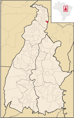
Aguiarnópolis

Aguiarnópolis
Aguiarnópolis
Bandera de Aguiarnópolis
Bandera

Escudo de Aguiarnópolis
Escudo

Mapa
Mapa
Coordenadas: 06°33′46″S 47°27′57″O / -6.56278, -47.46583Coordenadas: 06°33′46″S 47°27′57″O / -6.56278, -47.46583
Entidad Municipio
 • País Bandera de Brasil Brasil
 • Mesorregión Occidental del Tocantins
 • Microrregión Bico do Papagaio
Superficie  
 • Total 235.391 km²
Altitud  
 • Media 150 msnm
Población (est. IBGE/2009[1] )  
 • Total 4,216 hab.
 • Densidad 15,5 hab/km²
PIB (nominal)  
 • Total 23.174 mil
 • PIB per cápita 6.486,00
IDH (PNUD/2000[2] ) 0.629
Huso horario -3
Datos mesorregión IBGE/2008[3]
Datos microrregión IBGE/2008[3]
Dist. Cap. Km

Aguiarnópolis es un municipio brasilero del estado del Tocantins. Se localiza a una latitud 06º33'45" sur y a una longitud 47º27'59" oeste, estando a una altitud de 150 metros. Su población estimada en 2004 era de 3 449 habitantes.

Posee un área de 239,81 km².

Referencias

  1. . Instituto Brasilero de Geografía y Estadística (IBGE) (14 de agosto de 2009). Consultado el 16 de agosto de 2009.
  2. . Programa de las Naciones Unidas para el Desarrollo (PNUD) (2000). Consultado el 11 de octubre de 2008.
  3. a b . Instituto Brasilero de Geografía y Estadística (IBGE) (1 de julio de 2008). Consultado el 11 de octubre de 2008.

Wikimedia foundation. 2010.

Игры ⚽ Поможем сделать НИР

Mira otros diccionarios:

  • Aguiarnópolis — is a municipality located in the Brazilian state of Tocantins. Its population was 3,573 (2005) and its area is 235 km². [IBGE [http://www.ibge.gov.br/cidadesat/default.php] ] References …   Wikipedia

  • Aguiarnopolis — Admin ASC 2 Code Orig. name Aguiarnópolis Country and Admin Code BR.31.1700301 BR …   World countries Adminstrative division ASC I-II

  • Муниципалитеты штата Токантинс — …   Википедия

  • Агиарнополис — Муниципалитет Агиарнополис Aguiarnópolis Флаг Герб …   Википедия

  • Brazilian Highway System — The Brazilian Highway System is the highway system of Brazil, the fourth largest such system in the world. As of 2004, the system consists of almost 2 million km of roads, of which approximately 200,000 km are paved. The name given to highway in… …   Wikipedia

  • Liste der Gemeinden in Tocantins — Die untenstehenden Gemeinden liegen im brasilianischen Bundesstaat Tocantins. Die Zahl hinter den Namen ist die Bevölkerung im Gemeindegebiet in einer Schätzung des brasilianischen Bundesamtes für Statistik und Geographie (IBGE) für den 1. Juli… …   Deutsch Wikipedia

  • Commnes du Tocantins par population — Municipalités du Tocantins par population Liste des municipalités de l État du Tocantins par population, en ordre décroissant, selon l IBGE au 1er juillet 2005. Sommaire 1 Plus de 25 000 habitants 2 Plus de 10 000 habitants …   Wikipédia en Français

  • Communes du Tocantins par population — Municipalités du Tocantins par population Liste des municipalités de l État du Tocantins par population, en ordre décroissant, selon l IBGE au 1er juillet 2005. Sommaire 1 Plus de 25 000 habitants 2 Plus de 10 000 habitants …   Wikipédia en Français

  • Liste Des Villes Du Tocantins — Sommaire 1 Municipalités 1.1 A/L 1.2 M/X 2 Sources // …   Wikipédia en Français

  • Liste des municipes de l'état du Tocantins par population — Municipalités du Tocantins par population Liste des municipalités de l État du Tocantins par population, en ordre décroissant, selon l IBGE au 1er juillet 2005. Sommaire 1 Plus de 25 000 habitants 2 Plus de 10 000 habitants …   Wikipédia en Français

Compartir el artículo y extractos

Link directo
Do a right-click on the link above
and select “Copy Link”