Aldbury

Aldbury
Aldbury
Parroquia civil y pueblo del Reino Unido
AldburyPond.jpg
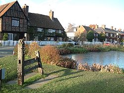
Vista de Aldbury.
Aldbury
Aldbury
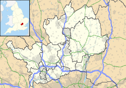
Ubicación de Aldbury en Hertfordshire.
51°48′8.8″N 0°36′7.1″O / 51.802444, -0.601972Coordenadas: 51°48′8.8″N 0°36′7.1″O / 51.802444, -0.601972
Entidad Parroquia civil y pueblo
 • País Bandera del Reino Unido Reino Unido
 • Nación constitutiva Inglaterra
 • Región Este de Inglaterra
 • Condado Hertfordshire
 • Distrito Dacorum
Superficie  
 • Total 8,17 km²
Población (2001)  
 • Total 962 hab.
 • Densidad 117,75 hab/km²
Huso horario GMT (UTC0)
 • en verano BST (UTC +1)
Código postal HP23
Prefijo telefónico 01442

Aldbury es una parroquia civil y un pueblo del distrito de Dacorum, en el condado de Hertfordshire (Inglaterra).

Contenido

Geografía

Según la Oficina Nacional de Estadística británica, Aldbury tiene una superficie de 8,17 km².[1]

Demografía

Según el censo de 2001, Aldbury tenía 962 habitantes (47,82% varones, 52,18% mujeres) y una densidad de población de 117,75 hab/km². El 20,48% eran menores de 16 años, el 72,97% tenían entre 16 y 74, y el 6,55% eran mayores de 74. La media de edad era de 38,75 años. Del total de habitantes con 16 o más años, el 26,27% estaban solteros, el 60,65% casados, y el 13,07% divorciados o viudos.[2]

El 94,18% de los habitantes eran originarios del Reino Unido. El resto de países europeos englobaban al 2,08% de la población, mientras que el 3,74% había nacido en cualquier otro lugar. Según su grupo étnico, el 98,34% eran blancos, el 0,42% mestizos, el 0,93% asiáticos, y el 0,31% de cualquier otro salvo negros y chinos. El cristianismo era profesado por el 77,62%, el budismo por el 0,31%, el hinduismo por el 0,31%, el judaísmo por el 0,31%, y cualquier otra religión, salvo el islam y el sijismo, por el 0,31%. El 14,72% no eran religiosos y el 6,42% no marcaron ninguna opción en el censo.[1]

Había 395 hogares con residentes y 14 vacíos.[2]

Referencias

  1. a b Tablas: «Usual Resident Population (KS01) for Amalgamated Parishes», «Ethnic Group (KS06) for Amalgamated Parishes», «Country of Birth (KS05) for Amalgamated Parishes» y «Religion (KS07) for Amalgamated Parishes», disponibles para descarga aquí. Office for National Statistics (inglés).
  2. a b «Area: Aldbury CP (Parish)» (en inglés). Office for National Statistics. Consultado el 23 de octubre de 2011.

Enlaces externos


Wikimedia foundation. 2010.

Игры ⚽ Поможем написать курсовую

Mira otros diccionarios:

  • Aldbury — infobox UK place country = England static static image caption=The stocks and pond at the centre of the village latitude= 51.79 longitude= 00.60 official name =Aldbury population = shire district= shire county= Hertfordshire region= East of… …   Wikipedia

  • Aldbury Nowers — Infobox SSSI name=Aldbury Nowers aos=Hertfordshire interest=GBiological gridref=gbmappingsmall|TL349165 area=19.7 hectares notifydate=1990 http://www.natureonthemap.org.uk/map.aspx? ] Aldbury Nowers (gbmapping|TL349165) is a 19.7 hectare (48.7… …   Wikipedia

  • Primary schools in Dacorum — This article on Primary schools in Dacorum gives brief information on primary schools in the area of Dacorum Borough Council in Hertfordshire, England, that cater for pupils up to the age of 11. Most schools are county maintained junior mixed… …   Wikipedia

  • Dacorum Council election, 2011 — Dacorum Borough Council election, 2011 2007 ← 5 May 2011 (2011 05 05) …   Wikipedia

  • Dacorum — Not to be confused with Decorum. Borough of Dacorum   Borough, Non metropolitan district   A street in Hemel Hempstead, a town in Daco …   Wikipedia

  • Ashridge — is an estate and house in Hertfordshire, England; part of the land stretches into Buckinghamshire and it is close to the Bedfordshire border. It is situated in the Chiltern Hills, an Area of Outstanding Natural Beauty, about two miles (3 km)… …   Wikipedia

  • Tring railway station — Infobox UK station name = Tring code = TRI manager = London Midland locale = near Tring and Aldbury borough = Dacorum usage0405 = 0.452 usage0506 = 0.502 platforms = 5 start = October 1837Tring railway station is 1.5 miles outside the small town… …   Wikipedia

  • Dacorum local elections — Dacorum Borough Council in Hertfordshire, England is elected every four years. Since the last boundary changes in 2007, 51 councillors have been elected from 25 wards.[1] Contents 1 Political control 2 Council elections …   Wikipedia

  • Stocks House — A large Georgian mansion, built in 1773 which is the largest property in the village of Aldbury, Hertfordshire. It was built by owners of Stocks Farm and used as their family home for many years. From 1892 it was owned by British novelist Mary… …   Wikipedia

  • Newark Priory — The remains of Newark Priory Monastery information Order Augustinian Established between 1189 1199 …   Wikipedia

Compartir el artículo y extractos

Link directo
Do a right-click on the link above
and select “Copy Link”