Fire Island Pines

Fire Island Pines
Fire Island Pines
Cherry Grove
Área no incorporada de los Estados Unidos
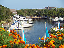
Fire Island Pines Shot 1.jpg
Marina de Fire Island Pines
Fire Island PinesCherry Grove
Fire Island Pines
Cherry Grove
Ubicación en el condado de Suffolk y en el estado de Nueva York
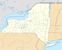
40°39′55″N 73°4′6″O / 40.66528, -73.06833Coordenadas: 40°39′55″N 73°4′6″O / 40.66528, -73.06833
Entidad Área no incorporada
 • País Bandera de los Estados Unidos Estados Unidos
 • Estado Flag of New York.svg Nueva York
 • Condado Suffolk
 • Pueblo Brookhaven
Superficie  
Población (2000)  
 • Total 310 hab.
 • Densidad ¿? hab/km²
Huso horario Este: UTC-5
 • en verano UTC-4
Prefijo telefónico 631
Sitio web oficial

Fire Island Pines y conocido también como Cherry Grove es un área no incorporada (o aldea) ubicada en el condado de Suffolk en el estado estadounidense de Nueva York. En el año 2000 tenía una población de 310 habitantes y en épocas temporales hasta 3 mil personas.

Geografía

Fire Island Pines se encuentra ubicada en las coordenadas 40°39′55″N 73°4′6″O / 40.66528, -73.06833.[1]

Referencias

  1. «U.S. Gazetteer: Censo de 2010» (en inglés). Oficina del Censo de los Estados Unidos (16 de febrero de 2011). Consultado el 11 de julio de 2011.

Enlaces externos


Wikimedia foundation. 2010.

Игры ⚽ Нужен реферат?

Mira otros diccionarios:

  • Fire Island Pines — Fire Island Pines …   Deutsch Wikipedia

  • Fire Island Pines, New York — Infobox Settlement official name = Fire Island Pines, New York settlement type = Hamlet nickname = motto = imagesize = 250px image caption = The marina from the west side shops area looking east caption= image pushpin pushpin label position =… …   Wikipedia

  • Fire Island — Situation de Fire Island. Géographie Pays …   Wikipédia en Français

  • Fire Island, New York — Infobox Settlement official name = Fire Island, New York settlement type = CDP nickname = motto = imagesize = image caption = image mapsize = 250x200px map caption = Fire Island mapsize1 = map caption1 = subdivision type = Country subdivision… …   Wikipedia

  • Fire Island — Im Vordergrund Fire Island, im Hintergrund Long Island …   Deutsch Wikipedia

  • Fire Island National Seashore — Infobox Protected area name = Fire Island National Seashore iucn category = V caption = locator x = 258 locator y = 63 location = Fire Island, New York, USA nearest city = Islip, New York lat degrees = 40 lat minutes = 41 lat seconds = 47 lat… …   Wikipedia

  • Invasion of the Pines — During the summer of 1976, a restaurant in Fire Island Pines, New York, denied entry to a visitor in drag named Terry Warren. Fire Island Pines is a beach community on Fire Island east of New York City with a gay majority population that was at… …   Wikipedia

  • Middle Island, New York —   CDP   U.S. Census Map …   Wikipedia

  • List of references to Long Island places in popular culture — Below is a list of references to Long Island locations in popular culture. Books *F. Scott Fitzgerald s The Great Gatsby takes place on the North Shore of Long Island. *Several books by Nelson DeMille, including Plum Island , The Gold Coast , The …   Wikipedia

  • Fire lookout tower — A fire lookout tower, fire tower or lookout tower, provides housing and protection for a person known as a fire lookout whose duty it is to search for fire in the wilderness. The fire lookout tower is a small building usually located on the… …   Wikipedia

Compartir el artículo y extractos

Link directo
Do a right-click on the link above
and select “Copy Link”