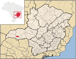
Comendador Gomes

Comendador Gomes
Comendador Gomes
Mapa
Mapa
Coordenadas: 19°41′52″S 49°04′51″O / -19.69778, -49.08083Coordenadas: 19°41′52″S 49°04′51″O / -19.69778, -49.08083
Entidad Municipio
 • País Bandera de Brasil Brasil
 • Estado Minas Gerais
 • Mesorregión Triángulo Minero/Alto Paranaíba
 • Microrregión Frutal
 • Fundación 27 de diciembre de 1948
Superficie  
 • Total 1.042,882 km²[1]
Población (Censo IBGE/2010[2] )  
 • Total 2.972 hab.
 • Densidad 2,85 hab/km²
PIB (nominal)  
 • Total 80.274,708 mil
 • PIB per cápita 24953.28
IDH (PNUD/2000[3] ) 0.795
Datos mesorregión IBGE/2008[4]
Datos microrregión IBGE/2008[4]
Municipios vecinos Prata, Itapagipe, Frutal, Campo Florido, Campina Verde

Comendador Gomes es un municipio brasileño del estado de Minas Gerais. Su población estimada en 2004 era de 2.779 habitantes.

Referencias

  1. . Resolução da Presidência do IBGE de n° 5 (R.PR-5/02) (10 out. 2002). Consultado el 5 diez. 2010.
  2. . Instituto Brasileiro de Geografia e Estatística (IBGE) (29 de noviembre de 2010). Consultado el 11 de diciembre de 2010.
  3. «Ranking decreciente del IDH-M de los municipios del Brasil». Programa das Nações Unidas para o Desenvolvimento (PNUD) (2000). Consultado el 11 de octubre de 2008.
  4. a b «División Territorial del Brasil». Instituto Brasileiro de Geografia e Estatística (IBGE) (1 de julio de 2008). Consultado el 11 de octubre de 2008.

Wikimedia foundation. 2010.

Игры ⚽ Нужен реферат?

Mira otros diccionarios:

  • Comendador Gomes — Location of Comendador Gomes in the state of Minas Gerais Comendador Gomes is a municipality in the west of the Brazilian state of Minas Gerais. As of 2007 the population was 3,087 in a total area of 1,043 km². It became a municipality in… …   Wikipedia

  • Comendador Gomes — Admin ASC 2 Code Orig. name Comendador Gomes Country and Admin Code BR.15.3116902 BR …   World countries Adminstrative division ASC I-II

  • Anexo:Ciudades de Brasil — Contenido: Arriba 0 9 A B C D E F G H I J K L M N Ñ O P Q R S T U V W X Y Z A Abadia de Goiás …   Wikipedia Español

  • Frutal — is a municipality in the north of the Brazilian state of Minas Gerais. As of 2007 the population was 51,766 in a total area of 2,430 km². It became a municipality in 1885.Micro region of FrutalFrutal is also a statistical micro region with 12… …   Wikipedia

  • Муниципалитеты штата Минас-Жерайс — …   Википедия

  • Комендадор-Гомис — Муниципалитет Комендадор Гомис Comendador Gomes Страна БразилияБразилия …   Википедия

  • Cordisburgo —   Municipality and town   Seal …   Wikipedia

  • List of postal codes in Brazil — These are list of postal codes in Brazil. Since 1993, the eight digit form was introduced, prior to 1993, the Brazilian postal codes formerly used the five digit form. Unlike the North American, some European and some other postal/ZIP codes, the… …   Wikipedia

  • Coronel Fabriciano —   Municipality   The Municipality of Coronel Fabriciano …   Wikipedia

  • Prata (Minas Gerais) — Prata is a Brazilian municipality located in the west of the state of Minas Gerais. Its population as of 2007 was 26,573 living in a total area of 4,856 km². The city belongs to the statistical mesoregion of Triângulo Mineiro and Alto Paranaíba… …   Wikipedia

Compartir el artículo y extractos

Link directo
Do a right-click on the link above
and select “Copy Link”