Gorst, Washington — Gorst is an unincorporated community at the head of Sinclair Inlet in Kitsap County, Washington, United States. No census population figures are available, since the town is not incorporated. Gorst, located on the shores of Puget Sound, is… … Wikipedia
Washington State Route 16 Spur — Infobox WA State Route|route=16 Spur|type=State|sec=065 marker dir1=South dir2=North length mi=0.39|length ref= [http://www.wsdot.wa.gov/mapsdata/tdo/PDF and ZIP Files/HwyLog2005B.pdf State Highway Log] , WSDOT, 2005 B] |length round=2 from= to=… … Wikipedia
Washington State Route 16 — Infobox WA State Route|type=State|route=16|sec=065 length mi=27.01 length ref= length round=2 formed=1964 dir1=East dir2=West from= junction= to= next type=State|previous type=State|next route=17|previous route=14 State Route 16 is a state… … Wikipedia
Washington State Route 16 — Karte … Deutsch Wikipedia
Washington State Route 106 — Karte … Deutsch Wikipedia
Washington State Route 3 — infobox WA State Route type=State route=3 sec=010 length mi=59.81 length ref= length round=2 formed=1964 dir1=South dir2=North from= junction= to= previous type=U.S. previous route=2 next type=State next route=4State Route 3 is a numbered state… … Wikipedia
Tacoma (Washington) — Die Einzelnachweise und die dort enthaltenen Weblinks bedarf einer Überarbeitung. Näheres ist auf der Diskussionsseite angegeben. Hilf mit, ihn zu verbessern, und entferne anschließend diese Markierung. Tacoma … Deutsch Wikipedia
Kitsap County, Washington — Infobox U.S. County county = Kitsap County state = Washington map size = 225 founded = January 16, 1857 seat = Port Orchard | area total sq mi =566 area land sq mi =396 area water sq mi =170 area percentage = 30.04% census yr = 2000 pop = 231969… … Wikipedia
List of unincorporated communities in Washington — This is a list of unincorporated communities in the U.S. state of Washington which are not incorporated municipalities. Incorporated municipalities in the state are listed separately in a list of cities and list of towns. Contents 1 Census… … Wikipedia
Olalla, Washington — This article is about the community in Washington. For the community in British Columbia, see Olalla, British Columbia. Olalla Unincorporated community … Wikipedia
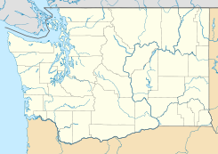
 Gorst
Gorst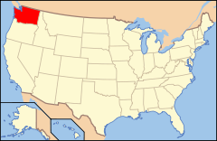
 Estados Unidos
 Washington
 Portal:Washington. Contenido relacionado con Washington.
 Wikimedia Commons alberga contenido multimedia sobre Gorst (Washington). Commons
