Great Doddington

Great Doddington
Great Doddington
Pueblo y parroquia civil del Reino Unido
HardwaterMill.JPG
Great Doddington
Great Doddington
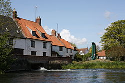
Ubicación en Northamptonshire.
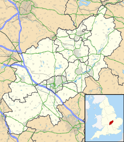
52°16′26.508″N 0°42′32.922″O / 52.27403, -0.709145Coordenadas: 52°16′26.508″N 0°42′32.922″O / 52.27403, -0.709145
Entidad Pueblo y parroquia civil
 • País Bandera del Reino Unido Reino Unido
 • Nación constitutiva Inglaterra
 • Región Midlands del Este
 • Condado Northamptonshire
 • Distrito Wellingborough
Población (2001)  
 • Total 1.061 hab.
Código postal NN29
Prefijo telefónico 01933

Great Doddington es un pueblo y una parroquia civil del distrito de Wellingborough, en el condado de Northamptonshire (Inglaterra).

Demografía

Según el censo de 2001,[1] Great Doddington tenía 1061 habitantes (527 varones y 534 mujeres). 169 de ellos (15,93%) eran menores de 16 años, 790 (74,46%) tenían entre 16 y 74, y 102 (9,61%) eran mayores de 74. La media de edad era de 43,06 años. De los 892 habitantes de 16 o más años, 175 (19,62%) estaban solteros, 599 (67,15%) casados, y 118 (13,23%) divorciados o viudos. 562 habitantes eran económicamente activos, 548 de ellos (97,51%) empleados y otros 14 (2,49%) desempleados. Había 10 hogares sin ocupar y 448 con residentes.

Evolución demográfica de Great Doddington
1801 1811 1821 1831 1841 1851 1861 1871 1881 1891 1901 1911 1921 1931 1941 1951 1961
311 376 442 442 474 493 - - 592 551 508 482 436 450 - 671 730
(Fuente:Vision of Britain )

Referencias

  1. «Great Doddington» (en inglés). Office for National Statistics. Consultado el 4 de julio de 2011.

Enlaces externos


Wikimedia foundation. 2010.

Игры ⚽ Нужно решить контрольную?

Mira otros diccionarios:

  • Great Doddington — is a village and civil parish within Northamptonshire in the United Kingdom, located close to Wellingborough and lying just off the A45. The name Dodda s Tun probably refers to an Anglo Saxon leader Dodda establishing a stronghold in the… …   Wikipedia

  • Doddington and Harby railway station — Doddington and Harby Location Area Nottinghamshire Operations Original company LD ECR Pre grouping Great Central Railway …   Wikipedia

  • Doddington, Cheshire — Coordinates: 53°01′37″N 2°26′17″W / 53.027°N 2.438°W / 53.027; 2.438 …   Wikipedia

  • Doddington (East Indiaman) — Career (Great Britain) …   Wikipedia

  • Wellingborough — Coordinates: 52°17′38″N 0°41′47″W …   Wikipedia

  • List of places in Northamptonshire — This is a list of places in the ceremonial county of Northamptonshire, United Kingdom. See the list of places in England for places in other counties See also compactTOC NOTOC AAbington Abthorpe Achurch Adstone Alderton Aldwincle Althorp… …   Wikipedia

  • Ranulf I de Soules — Ranulf de Soulis (Ranulf I de Soules) was a Norman knight who came to Scotland with David I. Some websites state that he had a daughter, Juliana, who married William de la Haye, the first Hay in Scotland. This would have made Ranulf an ancestor… …   Wikipedia

  • List of civil parishes in Northamptonshire — This is a list of civil parishes in Northamptonshire, England. Most parishes have their own parish council, but some smaller parishes may have a parish meeting, or may join together to form a combined parish council. Some larger parishes have… …   Wikipedia

  • NN postcode area — Northampton postcode area …   Wikipedia

  • Delapré Abbey — grid reference SP759592 Delapré Abbey the south front Delapré Abbey (The Abbey of the meadow), or more properly, the Convent of St Mary De La Pré, was founded as a Cluniac nunnery about the year 1145, si …   Wikipedia

Compartir el artículo y extractos

Link directo
Do a right-click on the link above
and select “Copy Link”