Hatherton

Hatherton
Hatherton
Parroquia civil y pueblo del Reino Unido
St. Saviour, Hatherton - geograph.org.uk - 146300.jpg
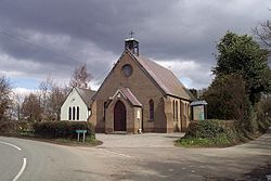
Iglesia de San Salvador, en Hatherton.
Hatherton
Hatherton
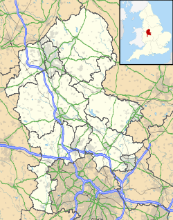
Ubicación de Hatherton en Staffordshire.
52°41′26.7″N 2°3′43.45″O / 52.69075, -2.0620694Coordenadas: 52°41′26.7″N 2°3′43.45″O / 52.69075, -2.0620694
Entidad Parroquia civil y pueblo
 • País Bandera del Reino Unido Reino Unido
 • Nación constitutiva Inglaterra
 • Región Midlands del Oeste
 • Condado Staffordshire
 • Distrito South Staffordshire
Superficie  
 • Total 8,29 km²
Población (2001)  
 • Total 532 hab.
 • Densidad 64,17 hab/km²
Huso horario GMT (UTC0)
 • en verano BST (UTC +1)
Código postal WS11
Prefijo telefónico 01543

Hatherton es una parroquia civil y un pueblo del distrito de South Staffordshire, en el condado de Staffordshire (Inglaterra).

Contenido

Geografía

Según la Oficina Nacional de Estadística británica, Hatherton tiene una superficie de 8,29 km².[1]

Demografía

Según el censo de 2001, Hatherton tenía 532 habitantes (49,62% varones, 50,38% mujeres) y una densidad de población de 64,17 hab/km². El 13,35% eran menores de 16 años, el 79,89% tenían entre 16 y 74, y el 6,77% eran mayores de 74. La media de edad era de 44,1 años. Del total de habitantes con 16 o más años, el 18,87% estaban solteros, el 67,46% casados, y el 13,67% divorciados o viudos.[2]

Según su grupo étnico, el 99,44% de los habitantes eran blancos y el 0,56% asiáticos. La mayor parte (98,68%) eran originarios del Reino Unido y el resto (1,32%) de cualquier otro lugar salvo los países europeos. El cristianismo era profesado por el 86,14% y el islam por el 0,56%, mientras que el 8,43% no eran religiosos y el 4,87% no marcaron ninguna opción en el censo.[1]

Había 212 hogares con residentes y 5 vacíos.[2]

Referencias

  1. a b Tablas: «Usual Resident Population (KS01) for Amalgamated Parishes», «Ethnic Group (KS06) for Amalgamated Parishes», «Country of Birth (KS05) for Amalgamated Parishes» y «Religion (KS07) for Amalgamated Parishes», disponibles para descarga aquí. Office for National Statistics (inglés).
  2. a b «Area: Hatherton CP (Parish)» (en inglés). Office for National Statistics. Consultado el 5 de septiembre de 2011.

Enlaces externos


Wikimedia foundation. 2010.

Игры ⚽ Нужно решить контрольную?

Mira otros diccionarios:

  • Hatherton — may refer to:* Hatherton, Cheshire * Hatherton, Staffordshire …   Wikipedia

  • Hatherton, Cheshire — Hatherton is a hamlet (at gbmappingsmall|SJ687474) and civil parish in the Crewe and Nantwich district of Cheshire, England. The hamlet is located 2¾ miles to the north east of Audlem and 3¾ miles to the south east of Nantwich. The parish also… …   Wikipedia

  • Hatherton Glacier — is a large glacier flowing from the Antarctic polar plateau generally eastward along the south side of the Darwin Mountains and entering Darwin Glacier at Junction Spur.Mapped by the Darwin Glacier Party of the Commonwealth Trans Antarctic… …   Wikipedia

  • Hatherton Canal — The Hatherton Canal is a derelict branch of the Staffordshire and Worcestershire Canal in south Staffordshire, England.When it was built it ran 4 miles (6 km) through eight locks from Hatherton Junction on the Staffordshire and Worcestershire… …   Wikipedia

  • Baron Hatherton — Baron Hatherton, of Hatherton in the County of Stafford, is a title in the Peerage of the United Kingdom. It was created in 1835 for the politician Edward John Littleton. He was Chief Secretary for Ireland from 1833 to 1834. Born Edward John… …   Wikipedia

  • Edward Littleton, 2nd Baron Hatherton — Edward Richard Littleton, 2nd Baron Hatherton (31 December 1815 – 2 April 1888), was a British peer and Liberal Member of Parliament.Hatherton was the son of Edward John Littleton, 1st Baron Hatherton, and Lady Hyacinth Mary Wellesley, daughter… …   Wikipedia

  • Edward Littleton, 1st Baron Hatherton — Edward John Littleton, 1st Baron Hatherton (March 18, 1791 ndash; May 4, 1863), was a British politician, of first the Tories and later the Whigs.Littleton was born Edward Walhouse, and was educated at Rugby and at Brasenose College, Oxford. In… …   Wikipedia

  • Wyrley and Essington Canal — For the restoration of the section Ogley Junction–Huddlesford Junction, see Lichfield Canal. Wyrley and Essington Canal Sneyd Wharf on the Wyrley and Essington Canal Original owner Birmin …   Wikipedia

  • Walsall Arboretum — is a Victorian public park located very close to Walsall town centre in the West Midlands. Part of the park and surrounding housing are covered by the Arboretum conservation area.History17th 19th centuriesUp until the 17th century, the Walsall… …   Wikipedia

  • Beacon sandstone — The Beacon sandstone is a geological formation exposed in Antarctica and deposited from the Devonian to the Triassic ( Ma|400| Ma|225Verify source|date=April 2008). The sandstone was originally described as a formation, and upgraded to group and… …   Wikipedia

Compartir el artículo y extractos

Link directo
Do a right-click on the link above
and select “Copy Link”