South Staffordshire

South Staffordshire
South Staffordshire
Distrito del Reino Unido
South Staffordshire Council Offices - geograph.org.uk - 515287.jpg
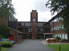
Oficinas del Ayuntamiento de South Staffordshire.
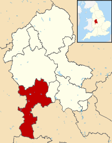
Ubicación en el condado de Staffordshire.
Entidad Distrito
 • País Bandera del Reino Unido Reino Unido
 • Nación constitutiva Inglaterra
 • Región Midlands del Oeste
 • Condado Staffordshire
Superficie  
 • Total 407,32 km²
Población (2001)  
 • Total 105 896 hab.
 • Densidad 259,98 hab/km²
Huso horario GMT (UTC0)
 • en verano BST (UTC +1)
Sede administrativa Codsall
Sitio web oficial

South Staffordshire es un distrito no metropolitano del condado de Staffordshire (Inglaterra). Fue constituido el 1 de abril de 1974 bajo la Ley de Gobierno Local de 1972 como una fusión de los distritos rurales de Cannock y Seisdon.

Contenido

Geografía

Según la Oficina Nacional de Estadística británica, South Staffordshire tiene una superficie de 407,32 km².[1]

Demografía

Según el censo de 2001,[1] South Staffordshire tenía 105 896 habitantes (49,32% varones, 50,68% mujeres) y una densidad de población de 259,98 hab/km². El 19,21% eran menores de 16 años, el 73,97% tenían entre 16 y 74, y el 6,83% eran mayores de 74. La media de edad era de 40,21 años.

Según su grupo étnico, el 98,04% de los habitantes eran blancos, el 0,59% mestizos, el 0,9% asiáticos, el 0,3% negros, el 0,11% chinos, y el 0,05% de cualquier otro. La mayor parte (97,78%) eran originarios del Reino Unido. El resto de países europeos englobaban al 1,09% de la población, mientras que el 0,24% había nacido en África, el 0,57% en Asia, el 0,2% en América del Norte, el 0,02% en América del Sur, el 0,08% en Oceanía, y el 0,01% en cualquier otro lugar. El cristianismo era profesado por el 83,53%, el budismo por el 0,1%, el hinduismo por el 0,24%, el judaísmo por el 0,03%, el islam por el 0,16%, el sijismo por el 0,47%, y cualquier otra religión por el 0,14%. El 9,24% no eran religiosos y el 6,09% no marcaron ninguna opción en el censo.

El 37,75% de los habitantes estaban solteros, el 48,91% casados, el 1,43% separados, el 5,46% divorciados y el 6,45% viudos. Había 41 973 hogares con residentes, de los cuales el 22,64% estaban habitados por una sola persona, el 7,82% por padres solteros con o sin hijos dependientes, el 68,6% por parejas (60,69% casadas, 7,92% sin casar) con o sin hijos dependientes, y el 0,94% por múltiples personas. Además, había 839 hogares sin ocupar y 57 eran alojamientos vacacionales o segundas residencias.

Referencias

  1. a b «Area: South Staffordshire (Local Authority)» (en inglés). Office for National Statistics. Consultado el 3 de septiembre de 2011.

Enlaces externos


Wikimedia foundation. 2010.

Игры ⚽ Поможем написать курсовую

Mira otros diccionarios:

  • South Staffordshire — District Lage in Staffordshire Status District Region West Midlands Verw.grafschaft Staffordshire …   Deutsch Wikipedia

  • South Staffordshire — is a local government district in Staffordshire, England. The district lies to the north and west of Wolverhampton and the West Midlands, bordering Shropshire to the west and Worcestershire to the south. It contains no towns of major size and… …   Wikipedia

  • South Staffordshire — ▪ district, England, United Kingdom       district, administrative and historic county of Staffordshire, central England, immediately west of the West Midlands metropolitan area centred on Birmingham. A greenbelt area of rolling terrain, South… …   Universalium

  • South Staffordshire Water — PLC is a privately owned water company supplying water to parts of Staffordshire and the West Midlands, England. They are one of only three water companies that are recognised by the industry regulator, OFWAT, as displaying top efficiency (Band… …   Wikipedia

  • South Staffordshire local elections — South Staffordshire Council is elected every four years.Political controlNo overall control 1973 1976Conservative 1976 presentCouncil electionsSouth Staffordshire Council election 1999South Staffordshire Council election 2003South Staffordshire… …   Wikipedia

  • South Staffordshire Regiment — Infobox Military Unit unit name=The South Staffordshire Regiment (38th and 80th) caption= dates=1881 1959 country=Great Britain allegiance= branch= type=Infantry of the Line role= size= command structure=Mercian Brigade (1948 59) current… …   Wikipedia

  • South Staffordshire (UK Parliament constituency) — UK constituency infobox Name = South Staffordshire Map1 = SouthStaffordshire Map2 = Staffordshire Type = County Year = 1832, 1983 Entity =Staffordshire County =Staffordshire EP = West Midlands MP = Patrick Cormack Party = ConservativeSouth… …   Wikipedia

  • South Staffordshire Line — The South Staffordshire Line was a railway line that connected Lichfield in Staffordshire, England with Dudley, formerly in Worcestershire. However, it joined the Oxford, Worcester and Wolverhampton Railway s line just north of Dudley Station,… …   Wikipedia

  • South Staffordshire Railway — The South Staffordshire Railway was the railway company responsible for building several lines in and around the area of Staffordshire, England. The Chief Engineer was John Robinson McClean. After an Act of Parliament was passed to allow it, he… …   Wikipedia

  • Walsall Courier and South Staffordshire Gazette — is the earliest known newspaper to serve Walsall in the ancient county of Staffordshire, now the West Midlands.Established in 1855, it was published by Newey Foster of New Street . It was a weekly newspaper and only lasted one year before the… …   Wikipedia

Compartir el artículo y extractos

Link directo
Do a right-click on the link above
and select “Copy Link”