Himley

Himley
Himley
Parroquia civil y pueblo del Reino Unido
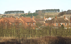
Rooftops and Hillside, Himley, Staffordshire - geograph.org.uk - 633959.jpg
Vista de Himley.
Himley
Himley
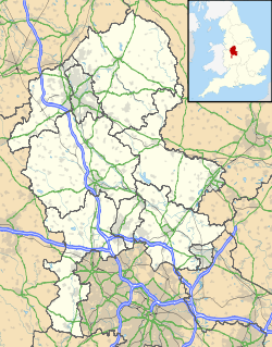
Ubicación de Himley en Staffordshire.
52°31′6.6″N 2°10′46.9″O / 52.5185, -2.179694Coordenadas: 52°31′6.6″N 2°10′46.9″O / 52.5185, -2.179694
Entidad Parroquia civil y pueblo
 • País Bandera del Reino Unido Reino Unido
 • Nación constitutiva Inglaterra
 • Región Midlands del Oeste
 • Condado Staffordshire
 • Distrito South Staffordshire
Superficie  
 • Total 8,86 km²
Población (2001)  
 • Total 713 hab.
 • Densidad 80,47 hab/km²
Huso horario GMT (UTC0)
 • en verano BST (UTC +1)
Código postal DY3
Prefijo telefónico 01902

Himley es una parroquia civil y un pueblo del distrito de South Staffordshire, en el condado de Staffordshire (Inglaterra).

Contenido

Geografía

Según la Oficina Nacional de Estadística británica, Himley tiene una superficie de 8,86 km².[1]

Demografía

Según el censo de 2001, Himley tenía 713 habitantes (43,34% varones, 56,66% mujeres) y una densidad de población de 80,47 hab/km². El 9,68% eran menores de 16 años, el 68,44% tenían entre 16 y 74, y el 21,88% eran mayores de 74. La media de edad era de 53,49 años. Del total de habitantes con 16 o más años, el 16,61% estaban solteros, el 59,01% casados, y el 24,38% divorciados o viudos.[2]

Según su grupo étnico, el 98,19% de los habitantes eran blancos, el 0,56% asiáticos, el 0,42% negros, el 0,42% chinos, y el 0,42% de cualquier otro salvo mestizos. La mayor parte (97,63%) eran originarios del Reino Unido. El resto de países europeos englobaban al 1,39% de la población, mientras que el 0,98% había nacido en cualquier otro lugar. El cristianismo era profesado por el 86,26% y el sijismo por el 0,56%, mientras que el 6,59% no eran religiosos y el 6,59% no marcaron ninguna opción en el censo.[1]

Había 242 hogares con residentes y 9 vacíos.[2]

Referencias

  1. a b Tablas: «Usual Resident Population (KS01) for Amalgamated Parishes», «Ethnic Group (KS06) for Amalgamated Parishes», «Country of Birth (KS05) for Amalgamated Parishes» y «Religion (KS07) for Amalgamated Parishes», disponibles para descarga aquí. Office for National Statistics (inglés).
  2. a b «Area: Himley CP (Parish)» (en inglés). Office for National Statistics. Consultado el 6 de septiembre de 2011.

Enlaces externos


Wikimedia foundation. 2010.

Игры ⚽ Поможем решить контрольную работу

Mira otros diccionarios:

  • Himley — Infobox UK place country = England official name= Himley latitude= 52.51791 longitude= 2.18415 shire district= South Staffordshire region= West Midlands shire county = Staffordshire constituency westminster= postcode district = DY3 postcode area …   Wikipedia

  • Himley Hall — is a country house situated in Staffordshire, England. It is situated in the south of the county, several miles from the larger towns of Dudley and Wolverhampton, although closer to villages including Sedgley, Kingswinford and Wombourne. It is a… …   Wikipedia

  • Himley railway station — Himley was a station on the Wombourne Branch Line. Unlike other stops along the route, it was deemed worthy of full station status. It was opened by the Great Western Railway in 1925 and closed in 1932. It served the community around Himley… …   Wikipedia

  • Himley Cricket Club — is an amateur cricket club in Himley, South Staffordshire, which is near Dudley. Their 1st XI is currently in the Birmingham and District Premier League Premier division, and their 2nd XI in the first division.They play their home games at… …   Wikipedia

  • Himley Park — is a public park situated in Staffordshire, England.It was created in the 1970s from the grounds of Himley Hall stately home, which is approximately four miles west of Dudley and six miles south of Wolverhampton.The park hosts numerous public… …   Wikipedia

  • Uchuu Keiji Shaider — infobox Television show name = Uchū Keiji Shaider caption = Uchuu Keiji Shaider format = Metal Hero Tokusatsu Action/Adventure camera = runtime = 30 minutes creator = developer = executive producer = starring = narrated = Toru Ohira country = JPN …   Wikipedia

  • Strange World Fuuma — is the name of an evil organization in Uchuu Keiji Shaider .HistoryA religion based from the Strange Palace in the Strange World dimension revering Kubilai as its god which intends to conquer the universe through psychological attacks. Kubilai… …   Wikipedia

  • Dudd Dudley — Dudd (Dud) Dudley (1600 ndash; 1684), was an English metallurgist, who fought on the Royalist side in the English Civil War as a soldier, military engineer, and supplier of munitions. He was one of the first Englishmen to smelt iron ore with coke …   Wikipedia

  • Dud Dudley — Contents 1 Background and early life 2 Ironmaster 2.1 The Great Mayday Flood …   Wikipedia

  • Gornal, West Midlands — Coordinates: 52°31′23″N 2°07′26″W / 52.523°N 2.124°W / 52.523; 2.124 …   Wikipedia

Compartir el artículo y extractos

Link directo
Do a right-click on the link above
and select “Copy Link”