Hyde Lea

Hyde Lea
Hyde Lea
Parroquia civil y pueblo del Reino Unido
Hyde Lea
Hyde Lea
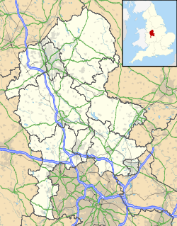
Ubicación de Hyde Lea en Staffordshire.
52°46′41.7″N 2°7′55.3″O / 52.77825, -2.132028Coordenadas: 52°46′41.7″N 2°7′55.3″O / 52.77825, -2.132028
Entidad Parroquia civil y pueblo
 • País Bandera del Reino Unido Reino Unido
 • Nación constitutiva Inglaterra
 • Región Midlands del Oeste
 • Condado Staffordshire
 • Distrito Stafford
Superficie  
 • Total 3,94 km²
Población (2001)  
 • Total 401 hab.
 • Densidad 101,78 hab/km²
Huso horario GMT (UTC0)
 • en verano BST (UTC +1)
Código postal ST18
Prefijo telefónico 01785

Hyde Lea es una parroquia civil y un pueblo del distrito de Stafford, en el condado de Staffordshire (Inglaterra).

Geografía

Según la Oficina Nacional de Estadística británica, Hyde Lea tiene una superficie de 3,94 km².[1]

Demografía

Según el censo de 2001, Hyde Lea tenía 401 habitantes (48,88% varones, 51,12% mujeres) y una densidad de población de 101,78 hab/km². El 14,21% eran menores de 16 años, el 71,57% tenían entre 16 y 74, y el 14,21% eran mayores de 74. La media de edad era de 46,93 años. Del total de habitantes con 16 o más años, el 19,48% estaban solteros, el 63,08% casados, y el 17,44% divorciados o viudos.[2]

Según su grupo étnico, el 97,78% de los habitantes eran blancos, el 0,74% mestizos, el 0,74% asiáticos, y el 0,74% negros. La mayor parte (98,25%) eran originarios del Reino Unido. El resto de países europeos englobaban al 0,75% de la población, mientras que el 1% había nacido en cualquier otro lugar. El cristianismo era profesado por el 82,96%, el budismo por el 0,74%, el hinduismo por el 0,74%, y cualquier otra religión, salvo el judaísmo, el islam y el sijismo, por el 0,74%. El 8,89% no eran religiosos y el 5,93% no marcaron ninguna opción en el censo.[1]

Había 148 hogares con residentes y 3 vacíos.[2]

Referencias

  1. a b Tablas: «Usual Resident Population (KS01) for Amalgamated Parishes», «Ethnic Group (KS06) for Amalgamated Parishes», «Country of Birth (KS05) for Amalgamated Parishes» y «Religion (KS07) for Amalgamated Parishes», disponibles para descarga aquí. Office for National Statistics (inglés).
  2. a b «Area: Hyde Lea CP (Parish)» (en inglés). Office for National Statistics. Consultado el 1 de octubre de 2011.

Wikimedia foundation. 2010.

Игры ⚽ Нужна курсовая?

Mira otros diccionarios:

  • Hyde Park Junior School — Infobox UK school name = Hyde Park Junior School size = latitude = longitude = dms = motto = motto pl = established = Spring 1904 approx = closed = c approx = type = Junior School religion = president = head label = head = Mrs Bernie Evans r head …   Wikipedia

  • Hyde, Bedfordshire — infobox UK place official name = Hyde country = England region = East of England population = 380 [Bedfordshire County Council, [http://www.bedfordshire.gov.uk/CouncilAndDemocracy/Statisticsandcensus/FactsAndFigures/PopulationEstimatesAndForecasts… …   Wikipedia

  • Michael Lea — Personal information Full name Michael Robert Lea Date of birth 4 November 1987 ( …   Wikipedia

  • Stafford — This article is about the town of Stafford, England. For the larger local government district see Borough of Stafford. For other uses, see Stafford (disambiguation) infobox UK place country = England official name= Stafford latitude= 52.8066… …   Wikipedia

  • Stafford (borough) — Stafford is a local government district with borough status in Staffordshire in England. It is named after and includes the town of Stafford. It also includes the smaller town of Stone and numerous villages.The borough was formed on April 1, 1974 …   Wikipedia

  • List of civil parishes in Staffordshire — This is a list of civil parishes in Staffordshire, England. Stoke on Trent is included in this list (though it is entirely unparished). =Cannock Chase= Cannock is unparished.* Brereton and Ravenhill * Bridgtown * Brindley Heath * Cannock Wood *… …   Wikipedia

  • Liste von Automobilmarken — Automobilmarken, kurz Automarken, sind die Handelsnamen, unter denen Automobil Hersteller Fahrzeuge vertreiben. Aufgelistet werden Hersteller von Pkw und Rennwagen, die Automobile gebaut haben, bauen oder bauen wollten. Nutzfahrzeuge werden in… …   Deutsch Wikipedia

  • List of night buses in London — Night buses in London are after hours versions of their daytime numerical equivalents, normally running the same route but with extensions at either end of the service. This is normally to provide a night service to destinations served by tube or …   Wikipedia

  • Tameside — Metropolitan Borough of Tameside   Metropolitan borough   Tameside Council Offices, in Ashton under Lyne …   Wikipedia

  • London [1] — London (spr. lonnd n; hierzu Stadtplan: »London, innere Stadt«, mit Registerblatt), Hauptstadt Englands und des britischen Reiches, die bevölkertste Stadt der Erde, liegt zu beiden Seiten der hier 180–275 m breiten Themse, 97 km oberhalb deren… …   Meyers Großes Konversations-Lexikon

Compartir el artículo y extractos

Link directo
Do a right-click on the link above
and select “Copy Link”