Ibirataia

Ibirataia
Ibirataia
Ibirataia.jpg 
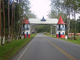
Entrada de la ciudad
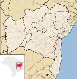
Mapa
Mapa
Coordenadas: 14°04′01″S 39°38′27″O / -14.06694, -39.64083Coordenadas: 14°04′01″S 39°38′27″O / -14.06694, -39.64083
Entidad Municipio
 • País Bandera de Brasil Brasil
 • Estado Bahía
 • Mesorregión Sur Bahiano
 • Microrregión Ilhéus-Itabuna
Fundación 10 de Noviembre 1960
Superficie  
 • Total 226,139 km²[1]
Clima caliente y umido
Población (IBGE/2010[2] )  
 • Total 18.946 hab.
 • Densidad 83,78 hab/km²
Gentilicio ibirataense
PIB (nominal)  
 • Total 94.764,197 mil
 • PIB per cápita 3855.02
IDH (PNUD/2000[3] ) 0.642
Datos mesorregión IBGE/2008[4]
Datos microrregión IBGE/2008[4]
Municipios vecinos Ipiaú, Gandu
Dist. Cap. 356

Ibirataia es un municipio brasileño localizado en el sur del estado de Bahía. Su población estimada en 2010 es de 18.881 habitantes.

Carreteras

  • BA-250

Referencias

  1. . Resolução da Presidência do IBGE de n° 5 (R.PR-5/02) (10 out. 2002). Consultado el 5 diez. 2010.
  2. . Instituto Brasileiro de Geografia e Estatística (IBGE) (29 de noviembre de 2010). Consultado el 11 de diciembre de 2010.
  3. «Ranking decreciente del IDH-M de los municipios del Brasil». Programa das Nações Unidas para o Desenvolvimento (PNUD) (2000). Consultado el 11 de octubre de 2008.
  4. a b «División Territorial del Brasil». Instituto Brasileiro de Geografia e Estatística (IBGE) (1 de julio de 2008). Consultado el 11 de octubre de 2008.

Enlaces externos


Wikimedia foundation. 2010.

Игры ⚽ Поможем сделать НИР

Mira otros diccionarios:

  • Ibirataia — Original name in latin Ibirataia Name in other language Tesouras, Ubirataia State code BR Continent/City America/Bahia longitude 14.06694 latitude 39.64056 altitude 151 Population 19942 Date 2012 08 03 …   Cities with a population over 1000 database

  • Ibirataia — Admin ASC 2 Code Orig. name Ibirataia Country and Admin Code BR.05.2912905 BR …   World countries Adminstrative division ASC I-II

  • Ipiaú — Infobox City official name = Ipiaú nickname = Model Bahia City motto = imagesize = 275px image caption = Saint Roch Church image mapsize = 275px map caption = Location of Ipiaú pushpin subdivision type = Region subdivision type1 = State… …   Wikipedia

  • Муниципалитеты штата Баия — …   Википедия

  • Ибиратая — Муниципалитет Ибиратая Ibirataia Флаг Герб …   Википедия

  • Mirante — is a municipality/county in the state of Bahia in Brazil. In 2004 it had a population of 16,476. See also Mirante do Paranapanema, in São Paulo v …   Wikipedia

  • Cruz das Almas — is a small city near Salvador, in the state of Bahia, in Brazil. In 2004, it had an estimated population of 56.000 inhabitants. Its climate is tropical, hot and humid. The economy is based on agriculture, especially tobacco, orange and cassava… …   Wikipedia

  • Quarteto em Cy — ( Quartet in c , a play on words due to poet and lyricist Vinicius de Moraes)is a vocal group originally composed of four sisters hailing from Ibirataia, a town located in the Brazilian state of Bahia: Cybele, Cylene, Cynara and Cyra their real… …   Wikipedia

  • Morro do Chapéu — is a small city in the Brazilian state of Bahia, 386 km northwest of its capital, Salvador, 1012 meters above the sea level, because of which it is one of the coolest towns in Bahia, with temperatures occasionally falling below 10 °C in the… …   Wikipedia

  • Correntina — is a town in the state of Bahia in Brazil, 500 km from Brasilia and 980 km from Salvador. History Correntina was first mentioned in the dispatches of the Entradistas and Bandereirantes who visited the city in 1700 and 1790. The Decree… …   Wikipedia

Compartir el artículo y extractos

Link directo
Do a right-click on the link above
and select “Copy Link”