- Iguatama
-
Iguatama 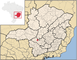
MapaCoordenadas: Coordenadas: Entidad Municipio • País  Brasil
• Estado Minas Gerais • Mesorregión Oeste de Minas • Microrregión Piuí • Fundación 1 de enero de 1944 Superficie • Total 627,819 km²[1] Altitud • Media 664 msnm Población (Censo IBGE/2010[2] ) • Total 8.031 hab. • Densidad 12,79 hab/km² Gentilicio iguatamense PIB (nominal) • Total 214.172,183 mil • PIB per cápita 27514.41 IDH (PNUD/2000[3] ) 0.786 Datos mesorregión IBGE/2008[4] Datos microrregión IBGE/2008[4] Municipios vecinos Arcos, Doresópolis, Bambuí, Pains Dist. Cap. 258 Iguatama es un municipio brasileño del estado de Minas Gerais. Su población estimada por el IGBE en 2007 era de 7632 habitantes.
Turismo
Su principal atracción es el río São Francisco, que atraviesa su territorio. Además hay varias lagunas que contribuyen para la preservación de especie de peces que sobreviven en el Río São Francisco. Una de estas lagunas de gran representación para la mantenimiento de esa biodiversidad es la Laguna de la Inhuma.
Referencias
- ↑ . Resolução da Presidência do IBGE de n° 5 (R.PR-5/02) (10 out. 2002). Consultado el 5 diez. 2010.
- ↑ . Instituto Brasileiro de Geografia e Estatística (IBGE) (29 de noviembre de 2010). Consultado el 11 de diciembre de 2010.
- ↑ «Ranking decreciente del IDH-M de los municipios del Brasil». Programa das Nações Unidas para o Desenvolvimento (PNUD) (2000). Consultado el 11 de octubre de 2008.
- ↑ a b «División Territorial del Brasil». Instituto Brasileiro de Geografia e Estatística (IBGE) (1 de julio de 2008). Consultado el 11 de octubre de 2008.
- Este artículo fue creado a partir de la traducción automática del artículo Iguatama de la Wikipedia en portugués, concretamente de esta versión, bajo licencia Creative Commons Atribución Compartir Igual 3.0 y GFDL.
Categoría:- Localidades de Minas Gerais

Wikimedia foundation. 2010.