Jangipur

Jangipur
Jangipur
Localidad de la India
Jangipur  জঙ্গিপুর
Jangipur
জঙ্গিপুর
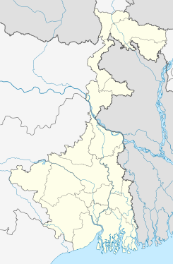
Ubicación de Jangipur en Bengala Occidental.
24°31′42″N 88°04′20″E / 24.52833, 88.07222Coordenadas: 24°31′42″N 88°04′20″E / 24.52833, 88.07222
Entidad Localidad
 • País Bandera de India India
 • Estado Bengala Occidental
 • Distrito Murshidabad
Altitud  
 • Media 24 msnm
Población (Est.2010[1] )  
 • Total 93.377 hab.
Huso horario IST UTC +5:30
PIN[2] 742213
Código de área 3483

Jangipur (en bengalí: জঙ্গিপুর ) es una ciudad de la India, en el distrito de Murshidabad, estado de Bengala Occidental.

Contenido

Geografía

Se encuentra a una altitud de 24 msnm a 285 km de la capital estatal, Calcuta, en la zona horaria UTC +5:30.

Demografía

Según estimación 2010 contaba con una población de 93 377 habitantes.[1]

Referencias

Enlaces externos


Wikimedia foundation. 2010.

Игры ⚽ Поможем сделать НИР

Mira otros diccionarios:

  • Jangipur — Original name in latin Jangipur Name in other language State code IN Continent/City Asia/Kolkata longitude 24.47001 latitude 88.07659 altitude 27 Population 82548 Date 2012 09 06 …   Cities with a population over 1000 database

  • Jangipur (Lok Sabha constituency) — Jangipur is a Lok Sabha constituency in West Bengal, India. Election resultsAssembly segmentsJangipur Lok Sabha constituency is composed of the following assembly segments [cite web url = http://archive.eci.gov.in/se2001/background/S25/WB Dist PC …   Wikipedia

  • Jangipur, Ghazipur — Infobox Indian Jurisdiction native name = Jangipur | type = city | latd = | longd = state name = Uttar Pradesh district = Ghazipur leader title = leader name = altitude = population as of = 2001 population total = 11,100| population density =… …   Wikipedia

  • Charka, Jangipur — Charka   town   …   Wikipedia

  • Murshidabad district — মুর্শিদাবাদ জেলা Location of Murshidabad district in West Bengal State …   Wikipedia

  • Jahangirpur, Murshidabad — Infobox Indian Jurisdiction native name = Jahangirpur | type = city | latd = 24.47 | longd = 88.07 locator position = right | state name = West Bengal district = Murshidabad leader title = leader name = altitude = 11 population as of = 2001… …   Wikipedia

  • Nabagram (Vidhan Sabha constituency) — For disambiguation, see Nabagram. Nabagram   Vidhan Sabha constituency   …   Wikipedia

  • Murshidabad —   city   …   Wikipedia

  • Dhulian —   city   …   Wikipedia

  • Murshidabad (Lok Sabha constituency) — (Bengali: মুর্শিদাবাদ লোকসভা কেন্দ্র) is a parliamentary constituency in Murshidabad district, West Bengal, India. Contents 1 Assembly segments 2 Election results 3 …   Wikipedia

Compartir el artículo y extractos

Link directo
Do a right-click on the link above
and select “Copy Link”