Karamadai

Karamadai
Karamadai
Localidad de la India
Karamadai  காரமடை
Karamadai
காரமடை
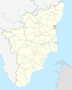
Ubicación de Karamadai en Tamil Nadu.
Ubicación de Tamil Nadu en India.
11°14′23″N 76°57′34″E / 11.23972, 76.95944Coordenadas: 11°14′23″N 76°57′34″E / 11.23972, 76.95944
Entidad Localidad
 • País Bandera de India India
 • Estado Tamil Nadu
 • Distrito Coimbatore
Altitud  
 • Media 369 msnm
Población (Est.2010[1] )  
 • Total 35.967 hab.
Huso horario IST UTC +5:30
PIN 641104

Karamadai (en tamil: காரமடை ) es una localidad de la India en el distrito de Coimbatore, estado de Tamil Nadu.

Contenido

Geografía

Se encuentra a una altitud de 369 msnm a 443 km de la capital estatal, Chennai, en la zona horaria UTC +5:30.

Demografía

Según estimación 2010 contaba con una población de 35 967 habitantes.[1]

Referencias

Enlaces externos


Wikimedia foundation. 2010.

Игры ⚽ Нужен реферат?

Mira otros diccionarios:

  • Karamadai — Infobox Indian Jurisdiction native name = Karamadai | type = city | latd = 11.27 | longd = 76.97 locator position = right | state name = Tamil Nadu district = Coimbatore leader title = leader name = altitude = 353 population as of = 2001… …   Wikipedia

  • Karamadai — Original name in latin Kramadai Name in other language Karamadai, Kramadai, karamatai State code IN Continent/City Asia/Kolkata longitude 11.24058 latitude 76.96009 altitude 367 Population 31188 Date 2013 07 31 …   Cities with a population over 1000 database

  • Mettupalayam, Coimbatore — This article is about a town in Coimbatore district. For other uses, see Mettupalayam. Mettupalayam   town   …   Wikipedia

  • Coimbatore — This article is about the city in Tamil Nadu, India. For its namesake district, see Coimbatore district. Coimbatore (கோயம்புத்தூர்) Manchester of South India   city   …   Wikipedia

  • Kotagiri —   city   …   Wikipedia

  • List of Hindu temples — Hindu temple is called Mandir or Kovil or Devasthanam or Dega (Nepal Bhasa) or Ambalam (Malayalam) or other words in different Indian languages. It is usually dedicated to a primary deity, called the presiding deity, and other deities associated… …   Wikipedia

  • Narasimhanaickenpalayam —   neighbourhood   Coordinates Country India State Tamil Nadu …   Wikipedia

  • Kil Kundha — Kil Kundha, ( Lower Kundha ) is one of the biggest hatties [ Villages ] in the Kundai Seemai ( region ), one of the four Seemais of the Nilgiri Hills of southern India. Kundai refers to the region comprising of fourteen villages of Kil Kundah,… …   Wikipedia

  • Ootacamund — Infobox Indian Jurisdiction native name = Udhagamandalam | type = city | latd = 11.38| longd = 76.90 locator position = right | state name = Tamil Nadu district = The Nilgiris leader title = leader name = altitude = 2213 population as of = 2001… …   Wikipedia

  • List of India-related articles — Articles (arranged alphabetically) related to India or Indian culture include: NOTOC List of India related topics People are listed by their first names. 1231 SGM 3 STR 2002 Gujarat violence 2005 in India ( previous years ) 2004 Indian Ocean… …   Wikipedia

Compartir el artículo y extractos

Link directo
Do a right-click on the link above
and select “Copy Link”