Khonsa — Infobox Indian Jurisdiction native name = Khonsa | type = city | latd = 27.02 | longd = 95.57 locator position = left | state name = Arunachal Pradesh district = Tirap leader title = leader name = altitude = 1215 population as of = 2001… … Wikipedia
Khonsa — Original name in latin Khonsa Name in other language Horu Khunma, Khela, Khonsa State code IN Continent/City Asia/Kolkata longitude 27.01667 latitude 95.56667 altitude 946 Population 10187 Date 2012 01 17 … Cities with a population over 1000 database
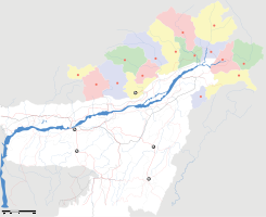
Tirap district — The Tirap district is located in the southeastern part of Arunachal Pradesh. It shares a state border with Nagaland and Assam, an international border with Myanmar and a district border with Changlang. Geography Much of the land lies not very far … Wikipedia
Nocte — Ethnic group group=Nocte Borduria, Jaipuria, Mohongia, Namsangia, Paniduria poptime=33,000 popplace=Tirap district, Arunachal Pradesh: 33,000 langs=Nocte, Assamese, English rels=Indigenous animist religion, Hinduism, Christianity (Baptist/other)… … Wikipedia
Arunachal East (Lok Sabha constituency) — Arunachal East Lok Sabha constituency is one of the two Lok Sabha (lower house of the Indian Parliament) constituencies in Arunachal Pradesh state in northeastern India. This constituency covers the entire Upper Siang, East Siang, Dibang Valley,… … Wikipedia
List of cities and towns in Arunachal Pradesh — Contents 1 Cities and towns in Changlang district 2 Cities and towns in Dibang Valley district 3 Cities and towns in East Kameng district 4 … Wikipedia
Masoud Nine — مسعود ناین Background information Also known as Masoud Nine Born December 27, 1989 (1989 12 27) (age 21) … Wikipedia
Nocte people — Nocte Alternative names: Borduria, Jaipuria, Mohongia, Namsangia, Paniduria Total population 33,000 Regions with significant populations Tirap district, Arunachal Pradesh: 33,000 Languages Nocte, Ass … Wikipedia
Districts of Arunachal Pradesh — Contents 1 History 2 Administrative set up 3 Districts 4 Notes History On December 1, 1965 the erstwhile North East Frontier Agency … Wikipedia
Deomali — city Coordinates Country India State Arunachal Pradesh … Wikipedia
 Khonsa
 India
India
