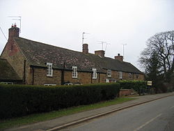
Lower Boddington — is a small village in South Northamptonshire. It is part of the civil parish of Boddington. Lower Boddington is the smaller of the two villages in the parish, although it does have a public house, the [http://www.thecarpentersarms.co.uk Carpenter … Wikipedia
Boddington, Northamptonshire — Boddington is a civil parish in the South Northamptonshire district of Northamptonshire, England. According to the 2001 census it had a population of 700. The parish includes the villages of Upper Boddington and Lower Boddington. Upper Boddington … Wikipedia
Upper Boddington — Pueblo del Reino Unido … Wikipedia Español
Upper Boddington — is a village situated in the South Northamptonshire district of Northamptonshire, England. It is in the parish of Boddington along with the smaller village of Lower Boddington.The village is located approximately 10 miles from Banbury, 18 miles… … Wikipedia
List of places in Northamptonshire — This is a list of places in the ceremonial county of Northamptonshire, United Kingdom. See the list of places in England for places in other counties See also compactTOC NOTOC AAbington Abthorpe Achurch Adstone Alderton Aldwincle Althorp… … Wikipedia
Aston le Walls — is a village and civil parish in the South Northamptonshire district of Northamptonshire, England, close by the border with Oxfordshire. According to the 2001 census it had a population of 334. The village is about nine miles north of Banbury in… … Wikipedia
Zones d'administration locale d'Australie-Occidentale — Les zones d administration locales d Australie Occidentale Il y a 141 zones d administration locale en Australie Occidentale si l on tient compte des deux comtés que sont le comté de l île Christmas et le comté des îles Cocos. Les fonctions de… … Wikipédia en Français
Marradong, Western Australia — Marradong Western Australia Established: 1890s Postcode: 6390 Location … Wikipedia
Mount Wells, Western Australia — Mount Wells Western Australia Established: 1920s Postcode: 6390 Location: 120 km (75 mi) from … Wikipedia
List of dams and reservoirs in the United Kingdom — Contents 1 England 1.1 Bedfordshire 1.2 Buckinghamshire 1.3 … Wikipedia
 Ubicación en Northamptonshire.
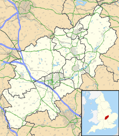
 Lower Boddington
 Reino Unido
 Wikimedia Commons alberga contenido multimedia sobre Lower Boddington. Commons
