- Luciára
-
Luciára 
Bandera
Escudo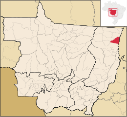
MapaCoordenadas: Coordenadas: Entidad Municipio • País  Brasil
• Mesorregión Nordeste Mato-Grossense • Microrregión Norte Araguaia Fundación 10 de mayo Superficie • Total 4,145.262 km² Altitud • Media 197 msnm Población (est. IBGE/2009[1] ) • Total 2,467 hab. • Densidad 0,5 hab/km² Gentilicio luciarense PIB (nominal) • Total 12.963 mil • PIB per cápita 6.114,00 IDH (PNUD/2000) 0,691 Huso horario -4 Datos mesorregión IBGE/2008[2] Datos microrregión IBGE/2008[2] Dist. Cap. 1.167Km
KmLuciara es un municipio brasilero del estado de Mato Grosso. Se localiza a la latitud 11º13'20" sur y a la longitud 50º40'09" oeste, estando a 197 metros de altitud. Su población estimada en 2009 era de 2 467 habitantes, distribuídos en 4662,87 km² de área.
Referencias
- Este artículo fue creado a partir de la traducción automática del artículo Luciára de la Wikipedia en portugués, concretamente de esta versión, bajo licencia Creative Commons Atribución Compartir Igual 3.0 y GFDL.
Categoría:- Municipios de Mato Grosso


Wikimedia foundation. 2010.