Maharajpur

Maharajpur
Maharajpur
Localidad de la India
Maharajpur
Maharajpur
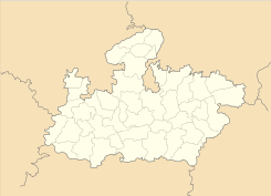
Ubicación de Maharajpur en Madhya Pradesh.
Ubicación de Madhya Pradesh en India.
25°00′46″N 79°43′45″E / 25.01278, 79.72917Coordenadas: 25°00′46″N 79°43′45″E / 25.01278, 79.72917
Entidad Localidad
 • País Bandera de India India
 • Estado Madhya Pradesh
 • Distrito Chhatarpur
Altitud  
 • Media 263 msnm
Población (Est.2010[1] )  
 • Total 23.530 hab.
Huso horario IST UTC +5:30
PIN[2] 471501

Maharajpur es una localidad de la India en el distrito de Chhatarpur, estado de Madhya Pradesh.

Contenido

Geografía

Se encuentra a una altitud de 263 msnm a 414 km de la capital estatal, Bhopal, en la zona horaria UTC +5:30.

Demografía

Según estimación 2010 contaba con una población de 23 530 habitantes.[1]

Referencias

Enlaces externos


Wikimedia foundation. 2010.

Игры ⚽ Поможем решить контрольную работу

Mira otros diccionarios:

  • Maharajpur — can refer to:*Maharajpur, Madhya Pradesh ndash; a town in Madhya Pradesh, India *Maharajpur district in Madhya Pradesh *Maharajpur, Haryana ndash; a town in Haryana, India …   Wikipedia

  • Maharajpur, Madhya Pradesh — Maharajpur   city   …   Wikipedia

  • Maharajpur (Vidhan Sabha constituency) — Maharajpur Vidhan Sabha constituency (Hindi: महाराजपुर विधान सभा निर्वाचन क्षेत्र) is one of the 230 Vidhan Sabha (Legislative Assembly) constituencies of Madhya Pradesh state in central India.[1] This constituency came in to existence in 1961,… …   Wikipedia

  • Maharajpur, Kanpur — Maharajpur   town   …   Wikipedia

  • Махараджпур — (Maharajpur) 1. Гвалиорская кампания Место сражения 29 дек. 1843 между 14 000 англичан (40 пушек) под командованием ген. сэра Хью Гофа и 18 000 солдат Бхагерат Рао Синдхии (100 пушек). Маратхи занимали прочные позиции в Махараджпуре, причем сэр… …   Энциклопедия битв мировой истории

  • Villages in the district Pilibhit — Villages in District Pilibhit= There are 1227 Villages in the district Pilibhit in four tehsils and seven blocks. The tehsils are Pilibhit, Barkhera, Puranpur, Bisalpur. The blocks in the district Pilibhit are Amaria, Barkhera, Bilsanda, Bisalpur …   Wikipedia

  • National Highway 2 (India) — NH 2 redirects here. NH 2 may also refer to New Hampshire s 2nd congressional district …   Wikipedia

  • Chhatarpur (Madhya Pradesh) (Vidhan Sabha constituency) — Chhatarpur Vidhan Sabha constituency (Hindi: छतरपुर विधान सभा निर्वाचन क्षेत्र) is one of the 230 Vidhan Sabha (Legislative Assembly) constituencies of Madhya Pradesh state in central India.[1] This constituency came in to existence in 1951, as… …   Wikipedia

  • List of RAF stations — This List of RAF stations is a comprehensive list of all stations, airbases, airfields and administrative headquarters of the Royal Air Force past and present.:Note Current RAF Stations will be listed under the currently recognised county of the… …   Wikipedia

  • Chhatarpur District — This article is about the district. For its eponymous headquarters, see Chhatarpur. Chhatarpur district छतरपुर जिला …   Wikipedia

Compartir el artículo y extractos

Link directo
Do a right-click on the link above
and select “Copy Link”