Mathabhanga

Mathabhanga
Mathabhanga
Localidad de la India
Mathabhanga  মাথাভাঙ্গা
Mathabhanga
মাথাভাঙ্গা
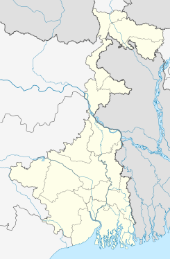
Ubicación de Mathabhanga en Bengala Occidental.
26°20′31″N 89°12′55″E / 26.34194, 89.21528Coordenadas: 26°20′31″N 89°12′55″E / 26.34194, 89.21528
Entidad Localidad
 • País Bandera de India India
 • Estado Bengala Occidental
 • Distrito Koch Bihar
Altitud  
 • Media 55 msnm
Población (Est.2010[1] )  
 • Total 24.532 hab.
Huso horario IST UTC +5:30
PIN[2] 736146
Código de área 3583

Mathabhanga (en bengalí: মাথাভাঙ্গা ) es una ciudad de la India, en el distrito de Koch Bihar, estado de Bengala Occidental.

Contenido

Geografía

Se encuentra a una altitud de 55 msnm a 702 km de la capital estatal, Calcuta, en la zona horaria UTC +5:30.

Demografía

Según estimación 2010 contaba con una población de 24532 habitantes.[1]

Referencias

Enlaces externos


Wikimedia foundation. 2010.

Игры ⚽ Нужна курсовая?

Mira otros diccionarios:

  • Mathabhanga —   city   …   Wikipedia

  • Mathabhanga subdivision —   subdistrict   …   Wikipedia

  • Mathabhanga (Vidhan Sabha constituency) — Mathabhanga   Vidhan Sabha constituency   …   Wikipedia

  • Mathabhanga I (community development block) — Mathabhanga I   community development block   …   Wikipedia

  • Mathabhanga II (community development block) — Mathabhanga II   community development block   …   Wikipedia

  • Mathabhanga River — The Mathabhanga River (Bengali : মাথাভাংগা নদী) Early History The Mathabhanga or Hauli, whose lower reach is called the Haulia, leaves the Padma about ten miles below the point where the Jalangi leaves from it. It flows first in a… …   Wikipedia

  • Cooch Behar district — This article is about the district. For its eponymous headquarters, see Cooch Behar. Cooch Behar district কোচবিহার জেলা Location of Cooch Behar district in West …   Wikipedia

  • Ichamati River — Geobox River name = Ichamati River native name = other name = other name1 = image size = image caption = View from Taki Guest House. The shores of Bangladesh are visible on the other side of Ichamati River. etymology = country = Bangladesh… …   Wikipedia

  • Cooch Behar (Lok Sabha constituency) — (Bengali: কোচবিহার লোকসভা কেন্দ্র) is one of the 543 parliamentary constituencies in India. The constituency centres on Cooch Behar in West Bengal. The seat is reserved for scheduled castes. Contents 1 Assembly segments 2 Election results …   Wikipedia

  • Cooch Behar II (community development block) — Cooch Behar II   community development block   …   Wikipedia

Compartir el artículo y extractos

Link directo
Do a right-click on the link above
and select “Copy Link”