Mid Suffolk

Mid Suffolk
Mid Suffolk
Distrito del Reino Unido
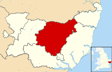
Mid Suffolk UK locator map.svg
Ubicación en el condado de Suffolk.
Entidad Distrito
 • País Bandera del Reino Unido Reino Unido
 • Nación constitutiva Inglaterra
 • Región Este de Inglaterra
 • Condado Suffolk
Superficie  
 • Total 871.07 km²
Población (2001)  
 • Total 86 837 hab.
 • Densidad 99,69 hab/km²

Mid Suffolk es un distrito no metropolitano del condado de Suffolk (Inglaterra). Tiene una superficie de 871,07 km². Según el censo de 2001, Mid Suffolk estaba habitado por 86 837 personas y su densidad de población era de 99,69 hab/km².[1]

Referencias

  1. «Find statistics for an area» (en inglés). Office for National Statistics. Consultado el 13 de agosto de 2011.

Wikimedia foundation. 2010.

Игры ⚽ Поможем написать курсовую

Mira otros diccionarios:

  • Mid Suffolk — District   Non metropolitan district   Mid Suffolk shown within Suffolk Sovereign state …   Wikipedia

  • Mid Suffolk — District Lage in Suffolk Status District Region East of England Verw.grafschaft Suffolk …   Deutsch Wikipedia

  • Mid Suffolk — ▪ district, England, United Kingdom       district, administrative and historic county of Suffolk, southeastern England. It occupies the central part of the county and is mainly an agricultural area of low, rolling hills. Cereals (including wheat …   Universalium

  • Mid-Suffolk Light Railway — Falmouth Docks in full steam. Locale England Terminus Bro …   Wikipedia

  • Mid Suffolk local elections — Mid Suffolk District Council in Suffolk, England is elected every four years. Since the last boundary changes in 2003, 40 councillors have been elected from 30 wards.[1] Contents 1 Political control 2 Council elections …   Wikipedia

  • Mid Suffolk Council election, 2011 — In the 2011 United Kingdom local elections, the Conservative Party held on to the Council for a third term while actually increasing their majority. The Liberal Democrats lost four seats but remained in second place while the Green Party and the… …   Wikipedia

  • Denham, Mid Suffolk — Coordinates: 52°18′40″N 1°11′49″E / 52.311°N 1.197°E / 52.311; 1.197 …   Wikipedia

  • Suffolk — Geografie Status: Zeremonielle und Verwaltungsgrafschaft Region: East of England Fläche: 3.801 km² Verwaltu …   Deutsch Wikipedia

  • Suffolk Coastal — District Lage in Suffolk Status District Region East of England Verw.grafschaft Suffolk …   Deutsch Wikipedia

  • Mid-Norfolk Railway — Steam hauled train on Danemoor Bank, 2011 Locale England Terminus Dereham Connections Breckland Line: near Wymondham …   Wikipedia

Compartir el artículo y extractos

Link directo
Do a right-click on the link above
and select “Copy Link”