Nyoma

Nyoma
Nyoma
Localidad de la India
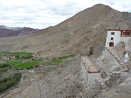
Monasterio en Nyoma
Nyoma
Nyoma
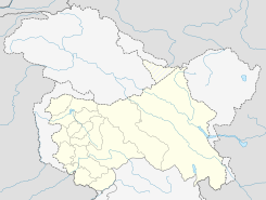
Ubicación de Nyoma en Jammu y Cachemira.
Ubicación de Jammu y Cachemira en India.
33°12′15″N 78°38′56″E / 33.20417, 78.64889Coordenadas: 33°12′15″N 78°38′56″E / 33.20417, 78.64889
Entidad Localidad
 • País Bandera de India India
 • Estado Jammu y Cachemira
 • Distrito Leh
Altitud  
 • Media 4184 msnm
Población (Est.2010[1] )  
 • Total 1.356 hab.
Huso horario IST UTC +5:30
PIN[2] 194101

Nyoma es una localidad de la India en el distrito de Leh, estado de Jammu y Cachemira.

Contenido

Geografía

Se encuentra a una altitud de 4 184 msnm a 185 km de la capital del distrito, Leh, en la zona horaria UTC +5:30.

Demografía

Según estimación 2010 contaba con una población de 1 356 habitantes.[1]

Referencias

Enlaces externos


Wikimedia foundation. 2010.

Игры ⚽ Поможем решить контрольную работу

Mira otros diccionarios:

  • Nyoma —   city   …   Wikipedia

  • Ньома — Город Ньома Nyoma Страна ИндияИндия …   Википедия

  • Ladakh —   region   …   Wikipedia

  • Leh — This article is about the municipality in India. For its namesake district, see Leh district. For other uses, see LEH (disambiguation). Leh लेह / གླེ་   city   …   Wikipedia

  • Nubra Valley —   valley   …   Wikipedia

  • Leh district — Leh is one of the two districts located in Ladakh, the other being the Kargil District to the west, in the state of Jammu and Kashmir, India. It is bounded on the north by Ghanche District (Northern Areas), a small border with Xinjiang, China,… …   Wikipedia

  • Changthang — simply meaning Northern Plateau in Tibetan, is a high altitude plateau western and northern Tibet and in eastern Ladakh, with vast highlands and giant lakes. From Eastern Ladakh Changthang stretches approximately 1600 km into Tibet. It is the… …   Wikipedia

  • Borota — Infobox Settlement settlement type = subdivision type = Country subdivision name = HUN latd= |latm= |lats= |latNS=N longd= |longm= |longs= |longEW=Epushpin pushpin label position = pushpin map caption = pushpin mapsize = timezone=CET utc… …   Wikipedia

  • Chemrey —   city   …   Wikipedia

  • More plains — is crossed by the road from Leh to Manali. This stretch of 40 km [1] falls in between Leh and Sarchu. This road has an average elevation of 4000 meters [2] and is flanked by mountain ranges on both sides. At some places the road runs along… …   Wikipedia

Compartir el artículo y extractos

Link directo
Do a right-click on the link above
and select “Copy Link”