Orlingbury

Orlingbury
Orlingbury
Pueblo y parroquia civil del Reino Unido
Orlingbury - geograph.org.uk - 82178.jpg
Orlingbury
Orlingbury
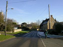
Ubicación en Northamptonshire.
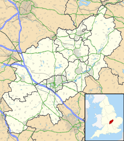
52°20′31.2426″N 0°44′18.5352″O / 52.342011833, -0.738482Coordenadas: 52°20′31.2426″N 0°44′18.5352″O / 52.342011833, -0.738482
Entidad Pueblo y parroquia civil
 • País Bandera del Reino Unido Reino Unido
 • Nación constitutiva Inglaterra
 • Región Midlands del Este
 • Condado Northamptonshire
 • Distrito Wellingborough
Población (2001)  
 • Total 395 hab.
Código postal NN14
Prefijo telefónico 01933

Orlingbury es un pueblo y una parroquia civil del distrito de Wellingborough, en el condado de Northamptonshire (Inglaterra).

Demografía

Según el censo de 2001,[1] Orlingbury tenía 395 habitantes (201 varones y 194 mujeres). 82 de ellos (20,76%) eran menores de 16 años, 290 (73,42%) tenían entre 16 y 74, y 23 (5,82%) eran mayores de 74. La media de edad era de 39,43 años. De los 313 habitantes de 16 o más años, 63 (20,13%) estaban solteros, 208 (66,45%) casados, y 42 (13,42%) divorciados o viudos. 198 habitantes eran económicamente activos, 195 de ellos (98,48%) empleados y otros 3 (1,52%) desempleados. Había 6 hogares sin ocupar y 152 con residentes.

Evolución demográfica de Orlingbury
1801 1811 1821 1831 1841 1851 1861 1871 1881 1891 1901 1911 1921 1931 1941 1951 1961
268 301 343 336 351 330 - - 285 288 255 233 252 305 - 285 248
(Fuente:Vision of Britain )

Referencias

  1. «Orlingbury» (en inglés). Office for National Statistics. Consultado el 3 de julio de 2011.

Enlaces externos


Wikimedia foundation. 2010.

Игры ⚽ Нужно сделать НИР?

Mira otros diccionarios:

  • Orlingbury — Coordinates: 52°20′22″N 0°44′02″W / 52.3394°N 0.7339°W / 52.3394; 0.7339 …   Wikipedia

  • Wythmail — Geobox|Lost Settlement name = Wythmail category = Lost settlement image caption = The location of Wythmail symbol = country = England state = Northamptonshire region = East of England district = Wellingborough municipality = Orlingbury location …   Wikipedia

  • Stagecoach in Northants — Stagecoach Northants Founded Connect Kettering (March 2006) Connect Wellingborough (October 2006) Headquarters Northampton, Northamptonshire Service area All Nort …   Wikipedia

  • Wellingborough — Coordinates: 52°17′38″N 0°41′47″W …   Wikipedia

  • Wellingborough (borough) — Infobox UK district name = Borough of Wellingborough status = Borough region = East Midlands admincounty = Northamptonshire area = Ranked 204th 163.04 km² adminhq = Wellingborough onscode = 34UH population = Ranked English district rank|ONS=34UH… …   Wikipedia

  • Ralph Lane — (1530 1603) was an English explorer of the Elizabethan era.Lane was born in Lympstone, Devon, England. His father was Sir Ralph of Orlingbury, and his mother, Maud, was a cousin of Catherine Parr, the last queen consort of Henry VIII.Lane… …   Wikipedia

  • List of places in Northamptonshire — This is a list of places in the ceremonial county of Northamptonshire, United Kingdom. See the list of places in England for places in other counties See also compactTOC NOTOC AAbington Abthorpe Achurch Adstone Alderton Aldwincle Althorp… …   Wikipedia

  • List of civil parishes in Northamptonshire — This is a list of civil parishes in Northamptonshire, England. Most parishes have their own parish council, but some smaller parishes may have a parish meeting, or may join together to form a combined parish council. Some larger parishes have… …   Wikipedia

  • Isham — is a village in Northamptonshire, England.Isham is situated on the A509 road, three miles south of Kettering (administratively it forms part of the borough of Wellingborough) and a mile to the west of Burton Latimer. A bypass west of the village… …   Wikipedia

  • Edward Maria Wingfield — Captain Edward Maria Wingfield, sometimes hyphenated as Edward Maria Wingfield , (born 1550 in Stonely, Huntingdonshire (now Cambridgeshire), England; died in 1631) [Date of Birth Burial. Birth: 1550: E150/102, p.3 Exchequer Copy (English), Lists …   Wikipedia

Compartir el artículo y extractos

Link directo
Do a right-click on the link above
and select “Copy Link”