Seighford

Seighford
Seighford
Parroquia civil y pueblo del Reino Unido
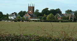
Seighford Village - geograph.org.uk - 57972.jpg
Vista de Seighford.
Seighford
Seighford
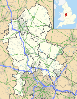
Ubicación de Seighford en Staffordshire.
52°49′18.4″N 2°10′37.9″O / 52.821778, -2.177194Coordenadas: 52°49′18.4″N 2°10′37.9″O / 52.821778, -2.177194
Entidad Parroquia civil y pueblo
 • País Bandera del Reino Unido Reino Unido
 • Nación constitutiva Inglaterra
 • Región Midlands del Oeste
 • Condado Staffordshire
 • Distrito Stafford
Superficie  
 • Total 18,71 km²
Población (2001)  
 • Total 1.750 hab.
 • Densidad 93,53 hab/km²
Huso horario GMT (UTC0)
 • en verano BST (UTC +1)
Código postal ST18

Seighford es una parroquia civil y un pueblo del distrito de Stafford, en el condado de Staffordshire (Inglaterra).

Contenido

Geografía

Según la Oficina Nacional de Estadística británica, Seighford tiene una superficie de 18,71 km².[1]

Demografía

Según el censo de 2001, Seighford tenía 1750 habitantes (48,51% varones, 51,49% mujeres) y una densidad de población de 93,53 hab/km². El 13,2% eran menores de 16 años, el 74,69% tenían entre 16 y 74, y el 12,11% eran mayores de 74. La media de edad era de 48,43 años. Del total de habitantes con 16 o más años, el 15,87% estaban solteros, el 68,07% casados, y el 16,06% divorciados o viudos.[2]

Según su grupo étnico, el 98,8% de los habitantes eran blancos, el 0,86% mestizos, y el 0,34% asiáticos. La mayor parte (96,57%) eran originarios del Reino Unido. El resto de países europeos englobaban al 1,26% de la población, mientras que el 2,17% había nacido en cualquier otro lugar. El cristianismo era profesado por el 85,79%, el hinduismo por el 0,17%, el islam por el 0,23%, el sijismo por el 0,17%, y cualquier otra religión, salvo el budismo y el judaísmo, por el 0,23%. El 7,48% no eran religiosos y el 5,94% no marcaron ninguna opción en el censo.[1]

Había 783 hogares con residentes y 22 vacíos.[2]

Referencias

  1. a b Tablas: «Usual Resident Population (KS01) for Amalgamated Parishes», «Ethnic Group (KS06) for Amalgamated Parishes», «Country of Birth (KS05) for Amalgamated Parishes» y «Religion (KS07) for Amalgamated Parishes», disponibles para descarga aquí. Office for National Statistics (inglés).
  2. a b «Area: Seighford CP (Parish)» (en inglés). Office for National Statistics. Consultado el 15 de octubre de 2011.

Enlaces externos


Wikimedia foundation. 2010.

Игры ⚽ Поможем написать реферат

Mira otros diccionarios:

  • Seighford — is a small village about three miles west of Stafford in Staffordshire, England. There is a red sandstone church (St. Chad s) there and a Tudor mansion. There is also a ford across a small stream, hence the village s name.Some very fine pictures… …   Wikipedia

  • High Sheriff of Staffordshire — This is a list of the High Sheriffs of Staffordshire.The High Sheriff is the oldest secular office under the Crown. Formerly the High Sheriff was the principal law enforcement officer in the county but over the centuries most of the… …   Wikipedia

  • Coton Clanford — is a small dispersed Staffordshire village lying in gently rolling countryside 3 miles due west of Stafford, England and 1 mile southeast of Seighford. The name of the village is sometimes hyphenated to Coton Clanford, appearing this way on some… …   Wikipedia

  • Cooper Perry Primary School — in Seighford, Stafford, England was founded in 1874 and provides an education based on traditional village school values within a stimulating yet safe environment. The school was re furbished and extended in 2001 as part of Staffordshire s first… …   Wikipedia

  • List of RAF stations — This List of RAF stations is a comprehensive list of all stations, airbases, airfields and administrative headquarters of the Royal Air Force past and present.:Note Current RAF Stations will be listed under the currently recognised county of the… …   Wikipedia

  • Stafford (borough) — Stafford is a local government district with borough status in Staffordshire in England. It is named after and includes the town of Stafford. It also includes the smaller town of Stone and numerous villages.The borough was formed on April 1, 1974 …   Wikipedia

  • List of civil parishes in Staffordshire — This is a list of civil parishes in Staffordshire, England. Stoke on Trent is included in this list (though it is entirely unparished). =Cannock Chase= Cannock is unparished.* Brereton and Ravenhill * Bridgtown * Brindley Heath * Cannock Wood *… …   Wikipedia

  • Doxey — Coordinates: 52°48′44″N 2°08′40″W / 52.8122°N 2.1444°W / 52.8122; 2.1444 …   Wikipedia

  • Stafford Rural District — infobox historic subdivision Name= Stafford Rural District HQ= Status= Rural district Start= 1894 End= 1974 Replace= PopulationFirst= 10,407 PopulationFirstYear= 1901 PopulationLast= 22,992 PopulationLastYear= 1971 AreaFirst=… …   Wikipedia

  • Stafford Borough Council Election, 2003 — Elections to Stafford Borough Council were held on 1 May 2003. All 59 seats on the council were up for election, with boundary changes meaning the number was reduced from 60. There were elections held in 24 wards, with a urther 2 wards (Church… …   Wikipedia

Compartir el artículo y extractos

Link directo
Do a right-click on the link above
and select “Copy Link”