Sergeevka

Sergeevka
Sergeevka
Bandera de
Bandera
Escudo de
Escudo
Sergeevka
Sergeevka
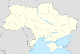
Localización de Sergeevka en Ucrania
País Bandera de Ucrania Ucrania
• Óblast Óblast de Odesa
Superficie 2,67 km²
Fundación 1946
Población 1.420 hab. (2001)
• Densidad 531,84 hab./km²

Sergeevka (ucraniano: Сергіївка) es una localidad del Raión de Sarata en el Óblast de Odesa de Ucrania. Según el censo de 2001, tiene una población de 1420 habitantes.

Referencias


Wikimedia foundation. 2010.

Игры ⚽ Поможем написать реферат

Mira otros diccionarios:

  • Sergeevka Audany — Admin ASC 2 Code Orig. name Sergeevka Aūdany Country and Admin Code KZ.16.1519383 KZ …   World countries Adminstrative division ASC I-II

  • Sergeyevka — 1 Original name in latin Sergeyevka Name in other language SERGEEVKA, Sergeevka, Sergeyevka, СЕРГЕЕВКА State code KZ Continent/City Asia/Almaty longitude 53.88261 latitude 67.41534 altitude 147 Population 8845 Date 2012 06 05 2 Original name in… …   Cities with a population over 1000 database

  • Парк Отель Виктория — (Sergeevka,Россия) Категория отеля: Адрес: Рязанская Область, Рязанский район …   Каталог отелей

  • Shal akyn District — Infobox Settlement name =Shal akyn settlement type =District official name = Шал ақын ауданы other name = native name = nickname = motto = imagesize = image caption = flag size = image seal size = image shield = shield size = image blank emblem …   Wikipedia

  • Serhijiwka — (Сергіївка) …   Deutsch Wikipedia

  • Будакский лиман — Шаболатский лиман на карте Шаболатский лиман (Будакский лиман)  лиман в Одесской области Украины, на побережье Чёрного моря. Расположен в 18 км от города Белгород Днестровский. Лиман отделён от моря узкой пересыпью шириной 80 200 метров. На… …   Википедия

  • North Kazakhstan Province — Солтүстік Қазақстан облысы Северо Казахстанская область   Province   …   Wikipedia

  • Historic Centre of Saint Petersburg and Related Groups of Monuments — Infobox World Heritage Site WHS = Historic Centre of Saint Petersburg and Related Groups of Monuments State Party = Type = Cultural Criteria = i, ii, iv, vi ID = 540 Region = Europe and North America Year = 1990 Session = 14th Link =… …   Wikipedia

  • Mamlyutka — (Kazakh: Мамлют) is a town (till 1969 village), that is the administrative center of Mamlyut District, North Kazakhstan Province, Kazakhstan. There is a railway station on the Kurgan Petropavlovsk line in the town. Coordinates: 54°56′29″N …   Wikipedia

  • Magzhan Zhumabaev District — Magzhan Zhumabaev   District   Мағжан Жұмабаев ауданы …   Wikipedia

Compartir el artículo y extractos

Link directo
Do a right-click on the link above
and select “Copy Link”