- Shenley
-
Shenley Parroquia civil y pueblo del Reino Unido 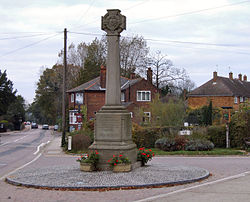
Monumento a los caídos de Shenley.Ubicación de Shenley en Hertfordshire.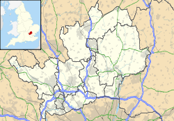
 Shenley
Coordenadas: Entidad Parroquia civil y pueblo • País  Reino Unido
• Nación constitutiva Inglaterra • Región Este de Inglaterra • Condado Hertfordshire • Distrito Hertsmere Superficie • Total 13,74 km² Población (2001) • Total 4.548 hab. • Densidad 331 hab/km² Huso horario GMT (UTC0) • en verano BST (UTC +1) Código postal WD7 Prefijo telefónico 01923 Shenley es una parroquia civil y un pueblo del distrito de Hertsmere, en el condado de Hertfordshire (Inglaterra).
Contenido
Geografía
Según la Oficina Nacional de Estadística británica, Shenley tiene una superficie de 13,74 km².[1]
Demografía
Según el censo de 2001, Shenley tenía 4548 habitantes (48,07% varones, 51,93% mujeres) y una densidad de población de 331 hab/km². El 24,36% eran menores de 16 años, el 69,13% tenían entre 16 y 74, y el 6,51% eran mayores de 74. La media de edad era de 34,68 años. Del total de habitantes con 16 o más años, el 27,06% estaban solteros, el 58,11% casados, y el 14,83% divorciados o viudos.[2]
El 86,52% de los habitantes eran originarios del Reino Unido. El resto de países europeos englobaban al 5,21% de la población, mientras que el 8,27% había nacido en cualquier otro lugar. Según su grupo étnico, el 91,14% eran blancos, el 2,44% mestizos, el 3,34% asiáticos, el 1,41% negros, el 0,95% chinos, y el 0,73% de cualquier otro. El cristianismo era profesado por el 64,42%, el budismo por el 0,64%, el hinduismo por el 1,56%, el judaísmo por el 12,14%, el islam por el 1,21%, el sijismo por el 0,44%, y cualquier otra religión por el 0,57%. El 11,79% no eran religiosos y el 7,23% no marcaron ninguna opción en el censo.[1]
Había 1675 hogares con residentes, 27 vacíos, y 3 eran alojamientos vacacionales o segundas residencias.[2]
Referencias
- ↑ a b Tablas: «Usual Resident Population (KS01) for Amalgamated Parishes», «Ethnic Group (KS06) for Amalgamated Parishes», «Country of Birth (KS05) for Amalgamated Parishes» y «Religion (KS07) for Amalgamated Parishes», disponibles para descarga aquí. Office for National Statistics (inglés).
- ↑ a b «Area: Shenley CP (Parish)» (en inglés). Office for National Statistics. Consultado el 29 de octubre de 2011.
Enlaces externos
 Wikimedia Commons alberga contenido multimedia sobre Shenley. Commons
Categorías:- Localidades de Hertfordshire
- Parroquias civiles de Hertfordshire

Wikimedia foundation. 2010.