Sihora

Sihora
Sihora
Localidad de la India
Sihora
Sihora
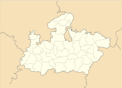
Ubicación de Sihora en Madhya Pradesh.
Ubicación de Madhya Pradesh en India.
23°29′11″N 80°06′12″E / 23.48639, 80.10333Coordenadas: 23°29′11″N 80°06′12″E / 23.48639, 80.10333
Entidad Localidad
 • País Bandera de India India
 • Estado Madhya Pradesh
 • Distrito Jabalpur
Altitud  
 • Media 392 msnm
Población (Est.2010[1] )  
 • Total 45.305 hab.
Huso horario IST UTC +5:30
PIN[2] 483225
Código de área 7624

Sihora es una localidad de la India en el distrito de Jabalpur, estado de Madhya Pradesh.

Contenido

Geografía

Se encuentra a una altitud de 392 msnm a 353 km de la capital estatal, Bhopal, en la zona horaria UTC +5:30.

Demografía

Según estimación 2010 contaba con una población de 45 305 habitantes.[1]

Referencias

Enlaces externos


Wikimedia foundation. 2010.

Игры ⚽ Поможем написать реферат

Mira otros diccionarios:

  • Sihora — Infobox Indian Jurisdiction native name = Sihora | type = city | latd = 23.48 | longd = 80.12 locator position = right | state name = Madhya Pradesh district = Jabalpur leader title = leader name = altitude = 386 population as of = 2001… …   Wikipedia

  • Sihora — Original name in latin Sihor Name in other language Sihora, Sihor State code IN Continent/City Asia/Kolkata longitude 23.48872 latitude 80.10348 altitude 393 Population 41192 Date 2012 11 08 …   Cities with a population over 1000 database

  • Easow Mar Timotheos Episcopa — Easow Mar Timotheos was an Episcopa ( bishop) of the Mar Thoma Church from 1975 to 1988. His missionary work before becoming a bishop was based on identifying himself with the economically backward people. He was engaged in poultry farming and… …   Wikipedia

  • Rewa Kantha Agency — Die Rewa Kantha Agency waren eine 1821 26 geschaffene administrative Gruppierung von indischen Fürstenstaaten, davon sechs größeren und 55 Zwergstaaten, zur Zeit der britischen Kolonialherrschaft. Im Süden grenzte sie an die Mewas, Teil des… …   Deutsch Wikipedia

  • Bhanwari Kaur — (b. ? d.1669) was a brave woman from Brij region in Uttar Pradesh, India who struggled against the oppression by Mugal ruler Aurangzeb in 1669. She was sister of Gokula, a Jat chieftain of Sinsini village in Bharatpur district in Rajasthan, India …   Wikipedia

  • List of Indian Princely States — Hundreds of princely states in British India existed prior to the independence of India and Pakistan (including the present Bangladesh) in 1947, ruled by semi independent potentates. Only four of the largest of these states were still directed by …   Wikipedia

  • List of India-related articles — Articles (arranged alphabetically) related to India or Indian culture include: NOTOC List of India related topics People are listed by their first names. 1231 SGM 3 STR 2002 Gujarat violence 2005 in India ( previous years ) 2004 Indian Ocean… …   Wikipedia

  • Jabalpur — Infobox Indian Jurisdiction native name = JABALPUR locator position = left latd = 23.15 longd = 79.97 state name = Madhya Pradesh district = Jabalpur leader title = Mayor leader name = Sushila Singh altitude = 1393 population as of = 2001… …   Wikipedia

  • Narsinghpur — This article is about the municipality in Madhya Pradesh, India. For its namesake district, see Narsinghpur District. Narsinghpur   city   …   Wikipedia

  • List of Scheduled Tribes in India — This is a full list of Scheduled Tribes in India, as recognised in India s Constitution; a total of 645 district tribes. The term Scheduled Tribes refers to specific indigenous peoples whose status is acknowledged to some formal degree by… …   Wikipedia

Compartir el artículo y extractos

Link directo
Do a right-click on the link above
and select “Copy Link”