Sloop Point

Sloop Point
Sloop Point
Área no incorporada de los Estados Unidos
Sloop Point
Sloop Point
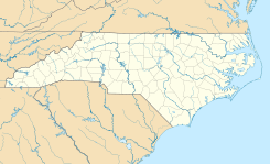
Ubicación en el condado de Pender y en el estado de Carolina del Norte
34°24′31″N 77°35′59″O / 34.40861, -77.59972Coordenadas: 34°24′31″N 77°35′59″O / 34.40861, -77.59972
Entidad Área no incorporada
 • País Bandera de los Estados Unidos Estados Unidos
 • Estado Flag of North Carolina.svg Carolina del Norte
 • Condado Pender
Superficie  
Huso horario Este: UTC-5/-4

Sloop Point es un área no incorporada ubicada del condado de Pender en el estado estadounidense de Carolina del Norte. Fue incorporado el 1 de julio de 1996 y, posteriormente, desincorporado el 22 de julio, 1998, lo que lo convierte en uno de los municipios de más corta duración en la historia del estado, que duró poco más de dos años.[1]

Referencias

  1. «U.S. Gazetteer: Censo de 2010» (en inglés). Oficina del Censo de los Estados Unidos (16 de febrero de 2011). Consultado el 11 de julio de 2011.

Enlaces externos

Coordenadas: 34°24′31″N 77°35′59″O / 34.40861, -77.59972


Wikimedia foundation. 2010.

Игры ⚽ Поможем написать курсовую

Mira otros diccionarios:

  • Sloop Point, North Carolina — Sloop Point is an unincorporated community in Pender County, North Carolina, United States. It was an incorporated village, incorporated on July 1, 1996 [http://www.ncga.state.nc.us/Sessions/1995/Bills/House/HTML/H1115v1.html] and subsequently… …   Wikipedia

  • SLOOP Project — SLOOP is an e Learning and OpenContent project, funded by the European Commission. It promotes the sharing of free/open learning objects. The original idea is to apply the free software philosophy to the production of pedagogical materials for e… …   Wikipedia

  • Sloop John B — Infobox Single Name = Sloop John B Cover size = Caption = Artist = The Beach Boys Album = Pet Sounds A side = B side = You re So Good to Me Released = March 21, 1966 Format = Vinyl Recorded = Western Studios July 12, 1965 December 22, 1966… …   Wikipedia

  • Hudson River Sloop Clearwater — Sloop Clearwater sailing up the Hudson River Career (United States) …   Wikipedia

  • Norfolk (sloop) — A replica of Norfolk The Colonial sloop Norfolk: “The necessity of a vessel to keep up a more frequent intercourse with Norfolk Island, …having been much felt by the want of various stores …occasioned Captain Townson, the Commanding officer, to… …   Wikipedia

  • Battle of Stony Point — The Battle of Stony Point was a battle of the American Revolutionary War.BackgroundIn late May, 1779, British Lieutenant General Sir Henry Clinton sent a force of about 8,000 men up the North (or Hudson) River with the intention of drawing… …   Wikipedia

  • Croton Point — is a Westchester County park in the village of Croton on Hudson. The park has several public attractions including: Miniature Aircraft airport Boat launch Cabin Rental Cross country skiing Fishing Group picnicking Hiking/walking Museum Nature… …   Wikipedia

  • Clark Point — (66°33′S 123°55′E / 66.55°S 123.917°E / 66.55; 123.917) is an ice covered headland at the east side of the entrance to Paulding Bay. It was delineated by G.D. Blodgett (1955) from aerial photog …   Wikipedia

  • National Register of Historic Places listings in Pender County, North Carolina — Map of all coordinates from Google Map of all coordinates from Bing …   Wikipedia

  • Pender County, North Carolina — Infobox U.S. County county = Pender County state = North Carolina map size = 250 founded = 1875 seat = Burgaw | area total sq mi =933 area water sq mi =62 area percentage = 6.64% census yr = 2000 pop = 41082 density km2 =18 web = www.pender… …   Wikipedia

Compartir el artículo y extractos

Link directo
Do a right-click on the link above
and select “Copy Link”