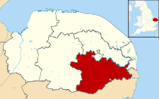
South Norfolk — District Lage in Norfolk Status District Region East of England Verw.grafschaft Norfolk … Deutsch Wikipedia
South Norfolk — is a local government district in Norfolk, England. Its council is based in Long Stratton.HistoryThe district was formed on April 1, 1974, under the Local Government Act 1972, as a merger of Diss Urban District, Wymondham Urban District, Depwade… … Wikipedia
South Norfolk — ▪ district, England, United Kingdom district, administrative and historic county of Norfolk, eastern England, occupying an area directly south of the city of Norwich. South Norfolk is principally an agricultural district extending across… … Universalium
South Norfolk, Virginia — South Norfolk was an independent city in the South Hampton Roads region of eastern Virginia and is now a section of the City of Chesapeake, one of the Seven Cities of Hampton Roads which surround the harbor of Hampton Roads and are linked by the… … Wikipedia
South Norfolk by-election — may refer to one of three by elections held for the British House of Commons constituency of South Norfolk: South Norfolk by election, 1898 South Norfolk by election, 1920 South Norfolk by election, 1955 See also List of United Kingdom by… … Wikipedia
South Norfolk (UK Parliament constituency) — This article is about South Norfolk Parliament constituency. For South Norfolk District Council, see South Norfolk. South Norfolk County constituency for the House of Commons … Wikipedia
South Norfolk by-election, 1955 — The South Norfolk by election, 1955 was a by election held on 13th January 1955 for the British House of Commons constituency of South Norfolk. The by election was triggered by the expulsion of the serving Conservative Member of Parliament (MP),… … Wikipedia
South Norfolk by-election, 1920 — The South Norfolk by election, 1920 was a by election held on 27 July 1920 for the British House of Commons constituency of South Norfolk. The by election was triggered by the succession to the peerage of the serving Coalition Liberal Member of… … Wikipedia
South Norfolk local elections — The South Norfolk Council, located in south Norfolk, England, is elected once every four years.Political controlIndependent 1973 1976No overall control 1976 1979Conservative 1979 1987No overall control 1987 1995Liberal Democrat 1995… … Wikipedia
South Norfolk Youth Symphonic Band — Infobox musical artist Name = South Norfolk Youth Symphonic Band Img capt = South Norfolk Youth Symphonic Band and the Band of the Army Air Corps outside Framlingham College. Img size = Landscape = Background = classical ensemble Alias = SNYSB… … Wikipedia

 Reino Unido