Sulgrave

Sulgrave
Sulgrave
Pueblo y parroquia civil del Reino Unido
The Star Inn Sulgrave - geograph.org.uk - 1356296.jpg
Sulgrave
Sulgrave
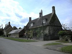
Ubicación en Northamptonshire.
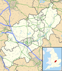
52°6′14.9652″N 1°11′15.4674″O / 52.104157, -1.187629833Coordenadas: 52°6′14.9652″N 1°11′15.4674″O / 52.104157, -1.187629833
Entidad Pueblo y parroquia civil
 • País Bandera del Reino Unido Reino Unido
 • Nación constitutiva Inglaterra
 • Región Midlands del Este
 • Condado Northamptonshire
 • Distrito South Northamptonshire
Población (2001)  
 • Total 410 hab.
Código postal OX17
Prefijo telefónico 01295

Sulgrave es un pueblo y una parroquia civil del distrito de South Northamptonshire, en el condado de Northamptonshire (Inglaterra).

Demografía

Según el censo de 2001,[1] Sulgrave tenía 410 habitantes (201 varones y 209 mujeres). 80 de ellos (19,51%) eran menores de 16 años, 288 (70,24%) tenían entre 16 y 74, y 42 (10,24%) eran mayores de 74. La media de edad era de 42,18 años. De los 330 habitantes de 16 o más años, 69 (20,91%) estaban solteros, 224 (67,88%) casados, y 37 (11,21%) divorciados o viudos. 205 habitantes eran económicamente activos, 198 de ellos (96,59%) empleados y otros 7 (3,41%) desempleados. Había 5 hogares sin ocupar, 168 con residentes y 4 eran alojamientos vacacionales o segundas residencias.

Evolución demográfica de Sulgrave
1801 1811 1821 1831 1841 1851 1861 1871 1881 1891 1901 1911 1921 1931 1941 1951 1961
414 437 578 576 560 604 - - 459 426 395 364 381 319 - 329 335
(Fuente:Vision of Britain )

Referencias

  1. «Sulgrave» (en inglés). Office for National Statistics. Consultado el 7 de julio de 2011.

Enlaces externos


Wikimedia foundation. 2010.

Игры ⚽ Нужно сделать НИР?

Mira otros diccionarios:

  • Sulgrave — infobox UK place country = England official name= Sulgrave latitude= 52.1031 longitude= 1.1839 static static image caption= Sulgrave Manor area total km2= 8.3 population density= Pop density km2 to mi2|49.4|precision=1|abbr=yes|wiki=yes area… …   Wikipedia

  • Sulgrave — geographical name village England in S Northamptonshire …   New Collegiate Dictionary

  • Church of St James the Less, Sulgrave — St James the Less, Sulgrave St James the Less, Sulgrave Coordinates …   Wikipedia

  • Lawrence Washington (1602-1655) — Lawrence Washington (1602 – 1655) was the great great grandfather of George Washington. Biography Washington was a Fellow of Brasenose College, Oxford. His degree there was awarded in 1623. He resigned from his Fellowship in 1633. According to… …   Wikipedia

  • Mike Long (American businessman) — For other people of the same name, see Michael Long. Mike Long is an American business man, former CEO of several public companies, and currently a founding partner of Sulgrave Partners LLC[1]. He served as the President and Chief Executive… …   Wikipedia

  • Morton Pinkney railway station — Morton Pinkney Location Place Moreton Pinkney Area South Northamptonshire Grid reference …   Wikipedia

  • Northamptonshire — Coordinates: 52°17′N 0°50′W / 52.283°N 0.833°W / 52.283; 0.833 …   Wikipedia

  • Helmdon — is a village in the district of South Northamptonshire in the English county of Northamptonshire.In 1969, 1996, 1999 and 2002 it won the Northamptonshire Village of the Year competition.Helmdon parish covers an area of approximately 6 square… …   Wikipedia

  • Hagioscope — A hagioscope (from Gr. άγιος , holy, and σκοπός , to see) or squint, in architecture, is an opening through the wall of a church in an oblique direction, to enable the worshippers in the transepts or other parts of the church, from which the… …   Wikipedia

  • East Midlands English — Modern boundaries of the English East Midlands. East Midlands English is a dialect traditionally spoken in those parts of English Midlands lying East of Watling Street (the A5 London Shrewsbury Road). Today this area is represented by the… …   Wikipedia

Compartir el artículo y extractos

Link directo
Do a right-click on the link above
and select “Copy Link”