- Surrency
-
Surrency Pueblo de los Estados Unidos 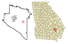
Ubicación en el condado de Appling en el estado de Georgia
Entidad Pueblo • País  Estados Unidos
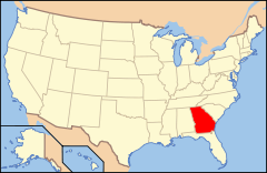
• Estado  Georgia
• Condado Appling Superficie • Total 2,0 km² • Tierra 2,0 km² • Agua 0,0 km² Altitud • Media 56 msnm Población (2000) • Total 237 hab. • Densidad 118.5 hab/km² Huso horario Este: UTC-5 • en verano UTC-4 Código ZIP 31563 Código de área 912 Surrency es un pueblo ubicado en el condado de Appling en el estado estadounidense de Georgia. En el censo de 2000, su población era de 316.
Demografía
En el 2000[1] la renta per cápita promedia del hogar era de $30,750, y el ingreso promedio para una familia era de $34,583. El ingreso per cápita para la localidad era de $14,794. Los hombres tenían un ingreso per cápita de $28,750 contra $26,563 para las mujeres.
Geografía
Surrency se encuentra ubicado en las coordenadas (31.724156, -82.198686)[2] .
Según la Oficina del Censo, la localidad tiene un área total de 2,0 km² (0,8 mi²), de la cual 2,0 km² (0,8 mi²) es tierra y 0,0 km² (0 mi²) (0.00%) es agua.[2]
Referencias
- ↑ «American FactFinder» (en inglés). Oficina del Censo de los Estados Unidos. Consultado el 11 de julio de 2011.
- ↑ a b «U.S. Gazetteer: Censo de 2010» (en inglés). Oficina del Censo de los Estados Unidos (16 de febrero de 2011). Consultado el 11 de julio de 2011.
Categorías:- Localidades del condado de Appling
- Pueblos de Georgia (Estados Unidos)


Wikimedia foundation. 2010.