- Foshay Tower
-
Coordenadas:
Foshay Tower 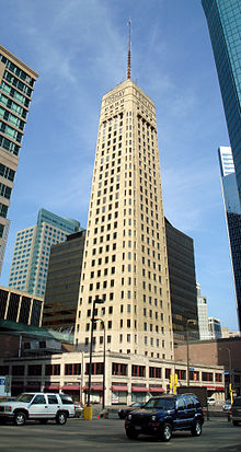
Edificio Localización Mineápolis,  Estados Unidos
Uso(s) Oficinas Construcción Construcción 1926-1929[1] Dimensiones Altura máxima 185.0[1] m Altura de la azotea 136.3[1] m Número de plantas 32[1] Equipo Arquitecto(s) Magney & Tusler El Foshay Tower, conocido ahora como W Minneapolis - The Foshay, es un rascacielos situado en el 821 Marquette Avenue de Mineápolis, Minnesota. La construcción del edificio finalizó en 1929; tiene 32 pisos y una altura de 136 metros. El edificio, que en 1978 se incluyó en el Registro Nacional de Lugares Históricos, es un ejemplo de arquitectura art decó.
Referencias
- ↑ a b c d «Foshay Tower» (en inglés). Consultado el 8 de octubre de 2011.
Enlaces externos
- Sitio oficial
- Foshay Tower
 Wikimedia Commons alberga contenido multimedia sobre Foshay Tower. Commons
- Este artículo fue creado a partir de la traducción automática del artículo Foshay Tower de la Wikipedia en italiano, concretamente de esta versión, bajo licencia Creative Commons Atribución Compartir Igual 3.0 y GFDL.
Categorías:- Rascacielos de Minnesota
- Arquitectura de 1929
- Art Deco

Wikimedia foundation. 2010.