Udalguri

Udalguri
Udalguri
Localidad de la India
Udalguri  ওদালগুৰি
Udalguri
ওদালগুৰি
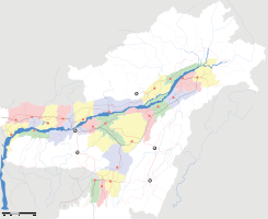
Ubicación de Udalguri en Assam.
Ubicación de Assam en India.
26°44′37″N 92°05′84″E / 26.74361, 92.10667Coordenadas: 26°44′37″N 92°05′84″E / 26.74361, 92.10667
Entidad Localidad
 • País Bandera de India India
 • Estado Assam
 • Distrito Udalguri
Altitud  
 • Media 110 msnm
Población (Est.2010[1] )  
 • Total 17.298 hab.
Huso horario IST UTC +5:30
PIN[2] 784509
Código de área 3711

Udalguri (en asamés: ওদালগুৰি ) es una localidad de la India, centro administrativo del distrito de Udalguri, estado de Assam.

Contenido

Geografía

Se encuentra a una altitud de 110 msnm a 125 km de la capital estatal, Dispur, en la zona horaria UTC +5:30.

Demografía

Según estimación 2010 contaba con una población de 17 298 habitantes.[1]

Referencias

Enlaces externos


Wikimedia foundation. 2010.

Игры ⚽ Нужна курсовая?

Mira otros diccionarios:

  • Udalguri — Infobox Indian Jurisdiction native name = Udalguri | type = city | latd = 26.77 | longd = 92.13 locator position = left | state name = Assam district = Udalguri|BTAD|Bodo Land Territorial Autonmous District leader title = leader name = altitude …   Wikipedia

  • Udalguri — Original name in latin Udalguri Name in other language Udalguri State code IN Continent/City Asia/Kolkata longitude 26.75367 latitude 92.10215 altitude 116 Population 15935 Date 2012 10 06 …   Cities with a population over 1000 database

  • Udalguri district — is one of the 27 districts of Assam state in north eastern India. Udalguri town is the headquarters of the district. This district is bounded by Bhutan and West Kameng district of Arunachal Pradesh state in the north, Sonitpur district in the… …   Wikipedia

  • Odalguri — Udalguri   city   …   Wikipedia

  • Bhairabkunda — Infobox Indian Jurisdiction native name = Bhairabkunda | type = city | latd = 26.8900 | longd = 92.1150 locator position = left | state name = Assam district = Udalguri|BTAD|Bodo Land Autonmous Area District leader title = leader name = altitude …   Wikipedia

  • Darrang district — দৰং   District   An entrance to Manas National Park, Darrang …   Wikipedia

  • Baksa district — (Assamese: বাক্সা জিলা) is one of the 27 districts of Assam state in north eastern India. Contents 1 History 2 Geography 3 Divisions 4 …   Wikipedia

  • Assam — Infobox Indian Jurisdiction type=state state name=Assam native name=Assam capital=Dispur latd = 26.15|longd=91.77 largest city=Guwahati abbreviation=IN AS official languages=Assamese, Bodo, Bengali (Barak Valley) legislature type=Unicameral… …   Wikipedia

  • Bodo people — The Bodos (pronounced BO ros) are an ethnic and linguistic community, early settlers of Assam in the North East of India. According to the 1991 census, there were 1.2 million Bodos in Assam which makes for 5.3% of the total population in the… …   Wikipedia

  • National Democratic Front of Bodoland — Flag of the National Democratic Front of Bodoland The National Democratic Front of Bodoland, also known as NDFB or the Bodo Security Force, is a terrorist outfit which seeks to obtain a sovereign Bodoland for the Bodo people in Assam, India. The… …   Wikipedia

Compartir el artículo y extractos

Link directo
Do a right-click on the link above
and select “Copy Link”