Banteay Kdei

Banteay Kdei

Banteay Kdei

Pix.gif Angkor1
Flag of UNESCO.svg
Patrimonio de la humanidad — Unesco
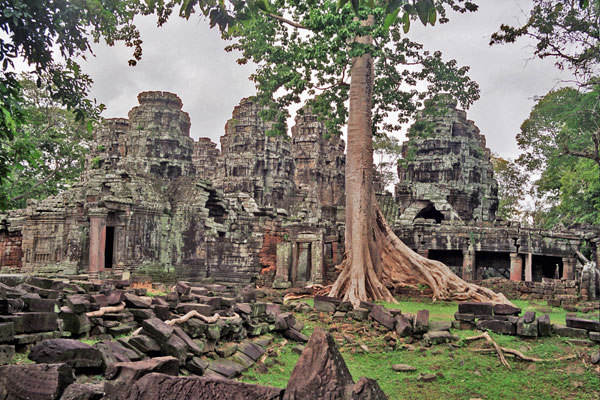
Banteay Kdei 7.jpg
El santuario central de Banteay Kdei.
Coordenadas 13°24′45″N 103°52′00″E / 13.4125, 103.866667
País Bandera de Camboya Camboya
Tipo Cultural
Criterios i, ii, iii, iv
N.° identificación 668
Región2 Asia y Oceanía
Año de inscripción 1992 (XVI sesión)
En peligro 1992-2004
1 Nombre como está inscrito en la Lista del patrimonio de la humanidad.
2 Clasificación según Unesco

Banteai Kdei es un templo budista situado en el complejo arqueológico de Angkor, a dos kilómetros de Angkor Thom en Camboya. Esta declarado Patrimonio de la Humanidad por la Unesco.

Historia

El templo se situa en el mismo emplazamiento de otro anterior, del siglo X. Prácticamente no hay documentación . Su construcción se desarrolló durante el reinado de Jayavarman VII (1160-1219) y de su sucesor, Indravarman II (1219-1243). No es una construcción unitaria, y se hicieron reformas. El estado de conservación del conjunto es regular, con zonas en ruinas y otras restauradas.

Bibliografía

  • Claude Jacques, Michael Freeman. Angkor cité khmère. Ed. Olizane. Ginebra, 2000. ISBN 2-88086-253-1
  • Jean Laur. Angkor. Flammarion. 2002. ISBN 2-820-0897-5
  • Maurice Glaize. Angkor. J. Maisonneuve. Paris, 2003. ISBN 2-7200-1091-X

Enlaces externos

Commons

Obtenido de "Banteay Kdei"

Wikimedia foundation. 2010.

Игры ⚽ Нужно решить контрольную?

Mira otros diccionarios:

  • Banteay Kdei — Apsara et devata Présentation Culte Boudhisme Début de la construction 1185 …   Wikipédia en Français

  • Banteay Kdei — ( km. បន្ទាយក្តី) is a temple at Angkor, Cambodia. It is located southeast of Ta Prohm and east of Angkor Thom. Built in the late 12th to early 13th centuriesCE during the reign of Jayavarman VII, it is a Buddhist temple in the Bayon style,… …   Wikipedia

  • Banteay Kdei — Mitte 12. bis Anfa …   Deutsch Wikipedia

  • Kambuja — Angkor Wat Angkor – Satellitenbild und Karte …   Deutsch Wikipedia

  • Angkor — Wat Angkor – Satellitenbild und Karte …   Deutsch Wikipedia

  • Architecture of Cambodia — The period of Angkor is the period from approximately the latter half of the 8th century A.D. to the first half of the 15th century. If precise dates are required, the beginning may be set in 802 A.D., when the Khmer King Jayavarman II pronounced …   Wikipedia

  • Architecture khmère — Principaux sites khmers L architecture khmère est un style très spécifique de construction inspiré des édifices religieux hindouistes de l Inde et qui affirma le caractère sacré du pouvoir des rois khmers déifiés (devarāja) par des temples… …   Wikipédia en Français

  • Srah Srang — 13° 25′ 52″ N 103° 54′ 25″ E / 13.431, 103.907 Srah Srang …   Wikipédia en Français

  • Angkor — Infobox World Heritage Site WHS = Angkor State Party = CAM Type = Cultural Criteria = i, ii, iii, iv ID = 668 Region = Asia Pacific Year = 1992 Session = 16th Danger = 1992 2004 Link = http://whc.unesco.org/en/list/668Angkor is a name… …   Wikipedia

  • Ta Som — Gopura mit Bildnis des Lokeshvara Überwuchertes östliches Eingangsportal …   Deutsch Wikipedia

Compartir el artículo y extractos

Link directo
Do a right-click on the link above
and select “Copy Link”