- Upper Heyford (Northamptonshire)
-
Upper Heyford Pueblo y parroquia civil del Reino Unido Ubicación en Northamptonshire.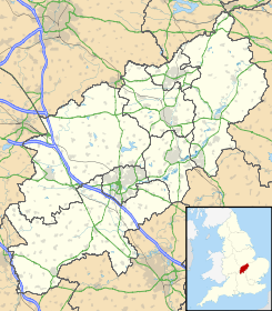
 Upper Heyford
Coordenadas: Entidad Pueblo y parroquia civil • País  Reino Unido
• Nación constitutiva Inglaterra • Región Midlands del Este • Condado Northamptonshire • Distrito South Northamptonshire Población (2001) • Total 77 hab. Código postal NN7 Prefijo telefónico 01327 Upper Heyford es un pueblo y una parroquia civil del distrito de South Northamptonshire, en el condado de Northamptonshire (Inglaterra).
Demografía
Según el censo de 2001, Upper Heyford tenía 77 habitantes (40 varones y 37 mujeres). 16 de ellos (20,78%) eran menores de 16 años, 58 (75,32%) tenían entre 16 y 74, y 3 (3,9%) eran mayores de 74. La media de edad era de 38,27 años. De los 61 habitantes de 16 o más años, 11 (18,03%) estaban solteros, 39 (63,94%) casados, y 11 (18,03%) divorciados o viudos.[1] 43 habitantes eran económicamente activos, todos ellos empleados.[2] Había 3 hogares sin ocupar y 33 con residentes.[3]
Evolución demográfica de Upper Heyford 1801 1811 1821 1831 1841 1851 1861 1871 1881 1891 1901 1911 1921 1931 1941 1951 1961 122 117 122 112 111 104 - - 115 96 88 96 102 109 - 100 68 (Fuente:Vision of Britain ) Referencias
- ↑ «Upper Heyford - People» (en inglés). Office for National Statistics. Consultado el 13 de julio de 2011.
- ↑ «Upper Heyford - Work and Qualifications» (en inglés). Office for National Statistics. Consultado el 13 de julio de 2011.
- ↑ «Upper Heyford - Accommodation and Tenure» (en inglés). Office for National Statistics. Consultado el 13 de julio de 2011.
Enlaces externos
 Wikimedia Commons alberga contenido multimedia sobre Upper Heyford. Commons
Categoría:- Localidades de Northamptonshire

Wikimedia foundation. 2010.