Upper Heyford (Oxfordshire)

Upper Heyford (Oxfordshire)
Upper Heyford
Pueblo y parroquia civil del Reino Unido
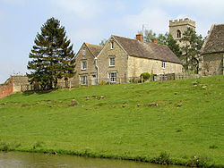
Upper Heyford - geograph.org.uk - 31587.jpg
Upper Heyford
Upper Heyford
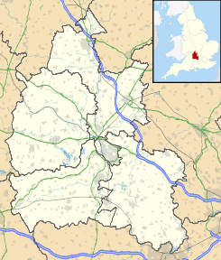
Ubicación en Oxfordshire.
51°55′44.9934″N 1°15′55.2594″O / 51.929164833, -1.265349833Coordenadas: 51°55′44.9934″N 1°15′55.2594″O / 51.929164833, -1.265349833
Entidad Pueblo y parroquia civil
 • País Bandera del Reino Unido Reino Unido
 • Nación constitutiva Inglaterra
 • Región Midlands del Este
 • Condado Oxfordshire
 • Distrito Cherwell
Población (2001)  
 • Total 1.154 hab.
Código postal OX25
Prefijo telefónico 01869

Upper Heyford es un pueblo y una parroquia civil del distrito de Cherwell, en el condado de Oxfordshire (Inglaterra).

Demografía

Según el censo de 2001,[1] Upper Heyford tenía 1154 habitantes (592 varones y 562 mujeres). 240 de ellos (20,8%) eran menores de 16 años, 879 (76,17%) tenían entre 16 y 74, y 35 (3,03%) eran mayores de 74. La media de edad era de 33,46 años. De los 914 habitantes de 16 o más años, 294 (32,16%) estaban solteros, 448 (49,02%) casados, y 172 (18,82%) divorciados o viudos. 706 habitantes eran económicamente activos, 686 de ellos (97,17) empleados y 20 (2,83%) desempleados. Había 25 hogares sin ocupar, 506 con residentes y 7 eran alojamientos vacacionales o segundas residencias.

Evolución demográfica de Upper Heyford
1801 1811 1821 1831 1841 1851 1861 1871 1881 1891 1901 1911 1921 1931 1941 1951 1961
217 230 257 326 337 399 - - 384 341 319 314 266 711 - 1504 2190
(Fuente:Vision of Britain )

Referencias

  1. «Upper Heyford» (en inglés). Office for National Statistics. Consultado el 14 de julio de 2011.

Enlaces externos


Wikimedia foundation. 2010.

Игры ⚽ Поможем решить контрольную работу

Mira otros diccionarios:

  • Upper Heyford, Oxfordshire — Upper Heyford is a village and civil parish in the Cherwell district of Oxfordshire, England.Upper Heyford is on the east bank of the River Cherwell. The term Upper was introduced to distinguish it from the other Heyford (Lower Heyford) which is… …   Wikipedia

  • Upper Heyford — El topónimo Upper Heyford puede hacer referencia a dos pueblos y parroquias de Inglaterra: Upper Heyford, en Northamptonshire; o Upper Heyford, en Oxfordshire. Esta página de desambiguación cataloga artículos relacionados con el mismo título. Si… …   Wikipedia Español

  • RAF Upper Heyford — Infobox Military Structure name= Royal Air Force Station Upper Heyford location= Located Near Upper Heyford, Oxfordshire, United Kingdom coordinates= caption= Welcome to RAF Upper Heyford 620th air base wing. This sign was seen at the entrance to …   Wikipedia

  • Oxfordshire (UK Parliament constituency) — Oxfordshire Former County constituency for the House of Commons County Oxfordshire 1290 (1290)–1885 …   Wikipedia

  • Oxfordshire Ironstone Railway — [v · d · …   Wikipedia

  • Lower Heyford — is a village and civil parish in the Cherwell district of Oxfordshire, England. The village is on the bank of the River Cherwell, and is close to Steeple Aston, Rousham and Upper Heyford. It is the site of sparsly served Heyford railway… …   Wikipedia

  • Mollington, Oxfordshire — Coordinates: 52°07′26″N 1°21′40″W / 52.124°N 1.361°W / 52.124; 1.361 …   Wikipedia

  • Mid Oxfordshire (UK Parliament constituency) — For the Mid Oxfordshire division that existed 1885 1918, see Woodstock (UK Parliament constituency). Mid Oxfordshire Former County constituency for the House of Commons February 1974 (February 1974)– …   Wikipedia

  • Merton, Oxfordshire — Coordinates: 51°51′18″N 1°09′50″W / 51.855°N 1.164°W / 51.855; 1.164 …   Wikipedia

  • Noke, Oxfordshire — Coordinates: 51°48′50″N 1°12′47″W / 51.814°N 1.213°W / 51.814; 01.213 …   Wikipedia

Compartir el artículo y extractos

Link directo
Do a right-click on the link above
and select “Copy Link”