Westelijke Polders

Westelijke Polders
Westelijke Polders
Nickerie resorts.png
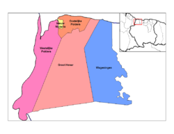
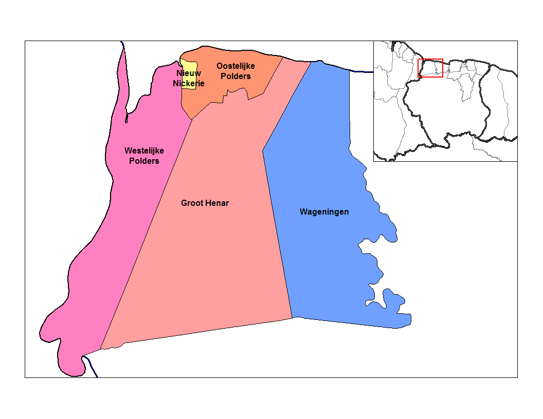
Distrito de Nickerie con Westelijke Polders en rosado.
País Surinam Bandera de Surinam
• Distrito Nickerie
• Suburbio Westelijke Polders
Población 9,046[1] hab. (2004)
Huso horario UTC-3

Westelijke Polders es uno de los cinco suburbios que componen el distrito de Nickerie en Surinam.[2]

En su sector noreste el suburbio de Westelijke Polders linda con los suburbios de Oostelijke Polders y Nieuw Nickerie, en el este con Groot Henar, en la sureste con el distrito de Sipaliwini y por el oeste con Guyana.

El suburbio de Westelijke Polders posee una población de 9,046 habitantes (Censo año 2004). Las localidades más populosas son Van Drimmelenpolder, Clarapolder, Zeedijk, Corantijnpolder, Van Pettenpolder, Zuiddrain y Nanipolder.


Referencias

  1. «Datos estadísticos de Westelijke Polders en statoids.com» (en inglés). Consultado el 30 de junio de 2010.
  2. Suriname.nu. «Sobre el estado de Nickerie» (en neerlandés). Consultado el 30 de junio de 2010.

Wikimedia foundation. 2010.

Игры ⚽ Нужно сделать НИР?

Mira otros diccionarios:

  • Oostelijke Polders — Distrito de Nickerie con Oostelijke Polder …   Wikipedia Español

  • Oostelijke Polders —   Resort   Map showing the resorts of Nickerie District. Country …   Wikipedia

  • Nickerie District — Map of Suriname showing Nickerie district Nickerie is a district of Suriname, on the north west coast. Nickerie s capital city is Nieuw Nickerie, the second largest city in the country. Other towns include Washoda and Wageningen. The district… …   Wikipedia

  • Nickerie — Capital Nieuw Nickerie Entidad Distrito …   Wikipedia Español

  • Isla Papegaaien — Papegaaien Eiland Localización País  Surinam Distrito Nickerie …   Wikipedia Español

  • Districts of Suriname — Suriname This article is part of the series: Politics and government of Suriname Constitution President …   Wikipedia

  • Commewijne District — Map of Suriname showing Commewijne district Commewijne is a district of Suriname, located on the right bank of the Suriname River. Commewijne s capital city is Nieuw Amsterdam. Alliance is another major town. The district has a population of… …   Wikipedia

  • Coronie District — Map of Suriname showing Coronie district Coronie is a district of Suriname, situated on the coast. Coronie s capital city is Totness, with other towns including Corneliskondre, Friendship, Jenny. The district border the Atlantic Ocean to the… …   Wikipedia

  • Marowijne District — Map of Suriname showing Marowijne district Marowijne is a district of Suriname, located on the north east coast. Marowijne s capital city is Albina, with other towns including Moengo and Wanhatti. The district borders the Atlantic Ocean to the… …   Wikipedia

  • Saramacca District — Coordinates: 5°46′57″N 55°37′29″W / 5.7825°N 55.62472°W / 5.7825; 55.62472 …   Wikipedia

Compartir el artículo y extractos

Link directo
Do a right-click on the link above
and select “Copy Link”