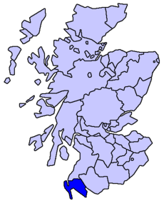
Wigtownshire

Wigtownshire
WigtownshireTraditional.png

Wigtownshire o el condado de Wigtown (escocés, Coontie o Wigtoun; gaélico, Siorrachd Bhaile na h-Uige) es un condado de registro en el suroeste de Escocia (Reino Unido). Limita con Ayrshire al norte, y el Stewartry of Kirkcudbright al este. Juntos The Stewartry y Wigtownshire son mencionados como Galloway: hasta el siglo XIX Wigtownshire fue también conocido a veces como West Galloway.[1] Tiene una superficie de 1.263 km², y su capital es Wigtown. Como Wigtown, es una lieutenancy area. La capital fue históricamente Wigtown. Con el establecimiento de un concejo condal en 1890, Stranraer, la ciudad más grande en el condado, se convirtió en el centro administrativo. Wigtown incluye la punta más meridional de Escocia, el Mull de Galloway, los Machars y la península de los Rhins de Galloway. La carretera principal que se une a la zona son la A77 al norte, y la A75 al este. Actualmente está administrada por el Concejo de Dumfries and Galloway. Hasta 1975 fue un condado.[cita requerida]

Principales ciudades

  • Newton Stewart
  • Stranraer
  • Whithorn
  • Wigtown

Otras localidades importantes

  • Ardwell
  • Sandhead
  • Castle Kennedy
  • Drummore
  • Glenluce
  • Kirkcowan
  • Portpatrick
  • Port William
  • New Luce

Referencias

  1. New Statistical Account of Scotland. (1834).

Coordenadas: 54°50′N 4°45′O / 54.833, -4.75


Wikimedia foundation. 2010.

Игры ⚽ Поможем сделать НИР

Mira otros diccionarios:

  • Wigtownshire — (spr. ŭiggtön schĭr, auch West Galloway), die südwestlichste Grafschaft Schottlands, im Westen und S. vom Irischen Meer bespült, grenzt im N. an Ayrshire, im O. an Kirkcudbrightshire, von dem es durch den in die Wigtownbai mündenden Cree getrennt …   Meyers Großes Konversations-Lexikon

  • Wigtownshire — Wigtown   County (until circa 1890)   Country Scotland …   Wikipedia

  • Wigtownshire — Lage von Wigtownshire in Schottland Wigtownshire ist eine traditionelle Grafschaft im äußersten Südwesten Schottlands. Historische Hauptstadt und namensgebender Ort ist die Stadt Wigtown, weitere bedeutende Orte sind Newton Stewart, Stranraer und …   Deutsch Wikipedia

  • Wigtownshire — 54°50′N 4°45′W / 54.833, 4.75 …   Wikipédia en Français

  • Wigtownshire — ▪ former county, Scotland, United Kingdom also called  Wigtown        historic county at the southwestern tip of Scotland, facing the Irish Sea to the south and the North Channel to the west. It is the western portion of the historic region of… …   Universalium

  • wigtownshire — ˈwigtənˌshi(ə)r, ˌtau̇n adjective or wigtown Usage: usually capitalized Etymology: from Wigtownshire or Wigtown, Scotland : of or from the county of Wigtown, Scotland : of the kind or style prevalent in Wigtown …   Useful english dictionary

  • Wigtownshire (UK Parliament constituency) — UK former constituency infobox Name = Wigtownshire Type = County Year = 1708 Abolition = 1918Wigtownshire, was a constituency of the House of Commons of the Parliament of Great Britain from 1708 to 1801 and of the Parliament of the United Kingdom …   Wikipedia

  • Wigtownshire RFC — Rugby team teamname = Wigtownshire union = Scottish Rugby Union fullname = Wigtownshire Rugby Football Club location = Stranraer, Scotland country founded = region = ground = London Road Playing Fields, Stranraer capacity = chairman = ceo =… …   Wikipedia

  • Wigtownshire — geographical name see Wigtown …   New Collegiate Dictionary

  • WIGTOWNSHIRE —    (36), the most southerly county in Scotland, in the SW. of which the largest town is Stranraer, and the county town Wigtown; it is an agricultural county, and largely pastoral …   The Nuttall Encyclopaedia

Compartir el artículo y extractos

Link directo
Do a right-click on the link above
and select “Copy Link”