Yupia

Yupia
Yupia
Localidad de la India
Yupia  युपिआ
Yupia
युपिआ
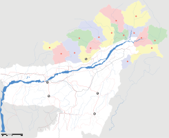
Ubicación de Yupia en Arunachal Pradesh.
Ubicación de Arunachal Pradesh en India.
27°07′53″N 93°44′38″E / 27.13139, 93.74389Coordenadas: 27°07′53″N 93°44′38″E / 27.13139, 93.74389
Entidad Localidad
 • País Bandera de India India
 • Estado Andhra Pradesh
 • Distrito Papum Pare
Altitud  
 • Media 135 msnm
Población (Est.2010[1] )  
 • Total 809 hab.
Huso horario IST UTC +5:30
PIN[2] 504302

Yupia (en hindi: युपिआ ) es una localidad de la India, centro administrativo del distrito de Papum Pare, estado de Arunachal Pradesh.

Contenido

Geografía

Se encuentra a una altitud de 135 msnm a 15 km de la capital estatal, Itanagar, en la zona horaria UTC +5:30.

Demografía

Según estimación 2010 contaba con una población de 809 habitantes.[1]

Referencias

Enlaces externos


Wikimedia foundation. 2010.

Игры ⚽ Нужна курсовая?

Mira otros diccionarios:

  • Yupia — is the headquarters of Papum Pare district in the state of Arunachal Pradesh in India. Yupia is about 20 km from Itanagar, the state capital …   Wikipedia

  • YUPIA — regio ampla Tartariae magnae, inter Oceanum Eoum ad Ortum et Tenducum regnum ad Occasum. Vix detecta versus oram littoralem ad Austrum. Yupi vulgo. Z …   Hofmann J. Lexicon universale

  • National Institute of Technology, Arunachal Pradesh — National Institute of Technology Arunachal Pradesh (also known as NIT Arunachal Pradesh) (Hindi: राष्ट्रीय प्रौद्योगिकी संस्थान, अरुणाचल प्रदेश) is one of the 30 National Institutes of Technology situated in Yupia, Arunanchal Pradesh. The classes …   Wikipedia

  • National Institutes of Technology — …   Wikipedia

  • Districts of Arunachal Pradesh — Contents 1 History 2 Administrative set up 3 Districts 4 Notes History On December 1, 1965 the erstwhile North East Frontier Agency …   Wikipedia

  • Papum Pare — is an administrative district in the state of Arunachal Pradesh in India. The district headquarters are located at Yupia. The district occupies an area of 2875 km² and has a population of 121,750 (as of 2001). The headquarters of the state is… …   Wikipedia

  • Department of Higher Education (India) — Department of Higher Education is the department under Ministry of Human Resource Development, that oversees higher education in India. The department is empowered to grant deemed university status to educational institutions on the advice of the …   Wikipedia

  • Arunachal Pradesh — Status: Bundesstaat Hauptstadt: Itanagar Fläche …   Deutsch Wikipedia

  • Liste der Distrikte in Indien — Die Liste der Distrikte in Indien ist nach Bundesstaaten und Unionsterritorien sortiert. Indien besteht aus 601 Distrikten. Die Distriktkürzel entsprechen der Norm ISO 3166 2 für die Kodierung subnationaler Einheiten. Sie werden für… …   Deutsch Wikipedia

  • List of cities and towns in Arunachal Pradesh — Contents 1 Cities and towns in Changlang district 2 Cities and towns in Dibang Valley district 3 Cities and towns in East Kameng district 4 …   Wikipedia

Compartir el artículo y extractos

Link directo
Do a right-click on the link above
and select “Copy Link”