Aadorf

Aadorf
Aadorf
Escudo de Aadorf
Escudo
País Flag of Switzerland.svg Suiza
• Cantón Wappen Thurgau matt.svg Turgovia
• Distrito Münchwilen
Ubicación 47°29′N 08°54′E / 47.483, 8.9
• Altitud 517 msnm
Superficie 20,0 km²
Población 7.986 hab. (2009[1] )
• Densidad 399 hab./km²
Lengua Alemán
Código postal 8355
Sitio web Sitio oficial

Aadorf es una comuna suiza del cantón de Turgovia, ubicada en el distrito de Münchwilen. Limita al norte con las comunas de Matzingen y Frauenfeld, al este con Wängi, al sur con Bichelsee-Balterswil y Turbenthal (ZH), y al oeste con Hofstetten bei Elgg (ZH), Elgg (ZH) y Hagenbuch (ZH).

Hasta el 31 de diciembre de 2010 situada en el distrito de Frauenfeld.

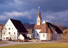
Claustro de Tänikon

Referencias

Enlaces externos


Wikimedia foundation. 2010.

Игры ⚽ Нужно сделать НИР?

Mira otros diccionarios:

  • Aadorf — Basisdaten Staat: Schweiz Kanton …   Deutsch Wikipedia

  • Aadorf — Une vue d ensemble de la commune serait la bienvenue Administration Pays Suisse Canton Thurgovie …   Wikipédia en Français

  • Aadorf — Aadorf, Dorf im schweizer. Kanton Thurgau, an der Eisenbahn St. Gallen Winterthur, mit Baumwollindustrie und (1900) 2695 Einw …   Meyers Großes Konversations-Lexikon

  • Aadorf — Aadorf,   Gemeinde im Kanton Thurgau, Schweiz, 528 m über dem Meeresspiegel, im nordöstlichen Mittelland, 3 900 Einwohner;   Wirtschaft:   Obstbau, vielseitige Industrie …   Universal-Lexikon

  • Aadorf — Infobox Swiss town subject name = Aadorf municipality name = Aadorf municipality type = municipality imagepath coa = Wappen Aadorf.svg|pixel coa= languages = German canton = Thurgau iso code region = CH TG district = Frauenfeld lat d=47|lat… …   Wikipedia

  • Aadorf — Original name in latin Aadorf Name in other language State code CH Continent/City Europe/Zurich longitude 47.49204 latitude 8.90099 altitude 526 Population 7620 Date 2013 03 28 …   Cities with a population over 1000 database

  • Aadorf — Sp Ãdorfas Ap Aadorf L Šveicarija …   Pasaulio vietovardžiai. Internetinė duomenų bazė

  • Guntershausen bei Aadorf — Wappen Basisdaten Kanton: Thurgau Bezirk: Frauenfeld …   Deutsch Wikipedia

  • Guntershausen (Aadorf) — Wappen Basisdaten Thurgau Bezirk: Münchwilen PLZ: 8357 …   Deutsch Wikipedia

  • Guntershausen bei Aadorf — is a village and former municipality in the district of Frauenfeld in the canton of Thurgau, Switzerland.It was first recorded in 1282 as Gundolthuser tal .The municipality also contained the villages Maischhausen, Tänikon and Wittershausen. It… …   Wikipedia

Compartir el artículo y extractos

Link directo
Do a right-click on the link above
and select “Copy Link”