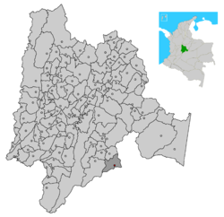
Guayabetal

Guayabetal
Guayabetal
Bandera de Guayabetal
Bandera
Escudo de Guayabetal
Escudo
MunsCundinamarca Guayabetal.png
País Bandera de Colombia Colombia
• Departamento Cundinamarca, Colombia (bandera).png Cundinamarca
• Provincia Oriente
Ubicación  
• Latitud 4º12`y 4º 19`norte
• Longitud 73º 45` y 73º 55`oeste
Temperatura 22° C
• Altitud 1210 msnm
Fundación 1789
Población 6.398 hab.
Gentilicio Guayabetaluno
Sitio web http://guayabetal-cundinamarca.gov.co

Guayabetal es un municipio de Cundinamarca (Colombia), ubicado en la Provincia de Oriente, se encuentra a 58km de Bogotá. Vino a formarse en el lugar que hoy ocupa durante la década de 1920 al 1930 dentro de la jurisdicción de Quetame y se consolidó con la carretera a Villavicencio.

Turismo

  • Las Cuchillas
  • Santuario Vírgen de Chirajara e Iglesia Nuestra Señora del Carmen
  • Caminos Reales
  • El limonar
  • Las playas de Rio Blanco
  • La meseta

Gobierno

  • Alcalde: Javier Ricardo Castro Duque

Enlaces externos


Wikimedia foundation. 2010.

Игры ⚽ Поможем решить контрольную работу

Mira otros diccionarios:

  • Guayabetal — is a municipality and town of Colombia in the department of Cundinamarca …   Wikipedia

  • Guayabetal — 4° 12′ 59″ N 73° 48′ 48″ W / 4.21638889, 73.81333333 …   Wikipédia en Français

  • Guayabetal — Original name in latin Guayabetal Name in other language Guayabetal State code CO Continent/City America/Bogota longitude 4.21472 latitude 73.81719 altitude 1087 Population 2017 Date 2012 01 19 …   Cities with a population over 1000 database

  • 2008 El Calvario earthquake — Date 24 May 2008 (2008 05 24) Magnitude 5.9 Mw …   Wikipedia

  • Cáqueza — Saltar a navegación, búsqueda Cáqueza Bandera …   Wikipedia Español

  • Sacaojal — Saltar a navegación, búsqueda Sacaojal es un antiguo nombre del actual municipio antioqueño de Olaya en la subregión del Occidente. Debe su nombre a la abundancia de zarzas que hacían jirones en la ropa. La historia del municipio arranca más o… …   Wikipedia Español

  • Cundinamarca Department — For the one from 1820 see Cundinamarca Department (1820). For the one from 1824 see Cundinamarca Department (1824). Cundinamarca Department Departamento de Cundinamarca   Department   …   Wikipedia

  • Municipalities of Colombia — The Municipalities of Colombia are decentralized subdivisions of the Republic of Colombia. Municipalities make up most of the departments of Colombia with 1,119 municipalities (municipios). Each one of them is led by a Mayor (Alcalde) elected by… …   Wikipedia

  • Chía, Cundinamarca — For other uses, see Chia. Chía Flag …   Wikipedia

  • Chaguani — Location of the town and municipality of Chaguani in Cundinamarca Department. Chaguani is a municipality and town of Colombia in the department of Cundinamarca …   Wikipedia

Compartir el artículo y extractos

Link directo
Do a right-click on the link above
and select “Copy Link”