Lexington (Kentucky)

Lexington (Kentucky)
Lexington, Kentucky
Bandera de Lexington (Kentucky)
Bandera
Escudo de Lexington (Kentucky)
Escudo
Panorama urbano de
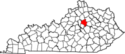
Location in the Commonwealth of Kentucky
Apodo: "Athens of the West" "Horse Capital of the World
Country Estados Unidos
• State Kentucky
• Counties Fayette
Ubicación 38°01′47″N 84°29′41″O / 38.02972, -84.49472Coordenadas: 38°01′47″N 84°29′41″O / 38.02972, -84.49472
• Altitud 298 msnm
Superficie  
• Total 739.5 km²
• Tierra firme 736.9 km²
• Agua 2.6 km²
Población  
• Total (2000) 260,512 hab.
• Metropolitana 429,889 hab.
• Densidad 353.5 hab./km²
Huso horario EST (UTC-5)
• Verano EDT (UTC-4)
Mayor Jim Newberry (D)

Lexington Es conocida como " La capital del caballo " ya que en esta ciudad se crían caballos de carreras y pura sangre. Es la segunda ciudad más poblada de Kentucky y la 69ª en todo Estados Unidos. Se localiza en la región conocida como "Blue Grass" en el condado de Fayette. En Lexington se encuentra el "Kentucky Horse Park", un enorme parque dedicado a la crianza de caballos pura sangre y de carreras, también el campo "Keeneland" Una enorme pista para que los caballos compitan en carreras. Además de la "Universidad de Transylvania" una Universidad muy prestigiada y la "Universidad de Kentucky" fundada en 1865 y la cual alberga a 27,209 estudiantes. En el censo del 2005 se obttuvo que la ciudad de Lexington tiene una población de 268,080. Lexington fue fundada en junio de 1775 en el Estado de Virginia, ya que en ese entonces Kentucky era parte de Virginia.


Wikimedia foundation. 2010.

Игры ⚽ Поможем написать курсовую

Mira otros diccionarios:

  • Lexington, Kentucky — Lexington   Consolidated city county   Lexington Fayette Urban County …   Wikipedia

  • Lexington (Kentucky) — Lexington Spitzname: Horse Capital of the World …   Deutsch Wikipedia

  • Lexington, Kentucky — Lexington (Kentucky) Pour les articles homonymes, voir Lexington. Lexington …   Wikipédia en Français

  • Lexington (Kentucky) — Pour les articles homonymes, voir Lexington. 38° 01′ 47″ N 84° 29′ 41″ W …   Wikipédia en Français

  • Cityscape of Lexington, Kentucky — Skyline of Lexington A portion of downtown Lexington in …   Wikipedia

  • Roads of Lexington, Kentucky — The roads of Lexington, Kentucky include Interstate 64 and Interstate 75, as their junction is near the city. There are five U.S. highways serving the city. A beltway surrounds central Lexington, while numerous state routes and connector roads… …   Wikipedia

  • Paul Laurence Dunbar High School (Lexington, Kentucky) — Infobox Education in the United States name= Paul Laurence Dunbar High School imagesize= motto= Where Excellence Meets Tradition! motto translation= streetaddress= 1600 Man O War Blvd city= Lexington state= Kentucky zipcode= 40513 areacode= 859… …   Wikipedia

  • Economy of Lexington, Kentucky — See also: List of major employers in Lexington, Kentucky The economy of Lexington, Kentucky was shaped by its considerable distance from any major navigable rivers. As a landlocked city, it did not develop the heavy industry that often developed… …   Wikipedia

  • List of people from Lexington, Kentucky — Following are notable people who were either born/raised or have lived for a significant period of time in the Lexington, Kentucky metropolitan area: Name Description David Akers National Football League kicker[1]. James L. Alcorn Deputy sheriff… …   Wikipedia

  • Christ Church Episcopal (Lexington Kentucky) — Christ Church Episcopal U.S. National Register of Historic Places …   Wikipedia

Compartir el artículo y extractos

Link directo
Do a right-click on the link above
and select “Copy Link”