Paragonah (Utah)

Paragonah (Utah)

Paragonah (Utah)

Paragonah es una localidad del condado de Iron, estado de Utah, Estados Unidos. Según el censo de 2000 la población era de 470 habitantes.

Geografía

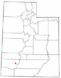
Localización de Paragonah, Utah

Paragonah se encuentra en las coordenadas37°53′8″N 112°46′27″O / 37.88556, -112.77417.

Según la oficina del censo de Estados Unidos, la localidad tiene una superficie total de 1,5 km². No tiene superficie cubierta de agua.

Enlaces externos

Obtenido de "Paragonah (Utah)"

Wikimedia foundation. 2010.

Игры ⚽ Нужно решить контрольную?

Mira otros diccionarios:

  • Paragonah, Utah — Infobox Settlement official name = Paragonah, Utah settlement type = Town nickname = motto = imagesize = image caption = image mapsize = 250px map caption = Location of Paragonah, Utah mapsize1 = map caption1 = subdivision type = Country… …   Wikipedia

  • Utah locations by per capita income — See also: List of cities in Utah Utah has the thirty ninth highest per capita income in the United States of America, at $18,185 (2000). Its personal per capita income is $24,977 (2003). Utah counties ranked by per capita income There are twenty… …   Wikipedia

  • Paragonah — Paragonah, UT U.S. town in Utah Population (2000): 470 Housing Units (2000): 197 Land area (2000): 0.580085 sq. miles (1.502412 sq. km) Water area (2000): 0.000000 sq. miles (0.000000 sq. km) Total area (2000): 0.580085 sq. miles (1.502412 sq.… …   StarDict's U.S. Gazetteer Places

  • Paragonah, UT — U.S. town in Utah Population (2000): 470 Housing Units (2000): 197 Land area (2000): 0.580085 sq. miles (1.502412 sq. km) Water area (2000): 0.000000 sq. miles (0.000000 sq. km) Total area (2000): 0.580085 sq. miles (1.502412 sq. km) FIPS code:… …   StarDict's U.S. Gazetteer Places

  • Utah State Route 271 — Infobox road state=UT type=SR route=271 section=133 maint=UDOT length mi=5.647 length round=3 length ref=cite web | title=State Route 271 Highway reference | publisher=Utah Department of Transportation | url=http://www.dot.utah.gov/main/uconowner …   Wikipedia

  • Utah State Route 20 — Infobox road state=UT type=SR route=20 section=107 maint=UDOT length mi=20.492 length round=3 length ref=cite web |url=http://www.dot.utah.gov/main/uconowner.gf?n=7214809725921777|title=Route Description 0020|format=pdf|accessdate=2008 01… …   Wikipedia

  • National Register of Historic Places listings in Iron County, Utah — Location of Iron County in Utah This is a list of the National Register of Historic Places listings in Iron County, Utah. This is intended to be a complete list of the properties and districts on the National Register of Historic Places in Iron… …   Wikipedia

  • Old Iron Town, Utah — Iron City   Ghost town   Ruins at Old Iron Town Nickname(s): Old Iron Town …   Wikipedia

  • Modena, Utah — Modena   Unincorporated community   …   Wikipedia

  • Newcastle, Utah — Newcastle   CDP   …   Wikipedia

Compartir el artículo y extractos

Link directo
Do a right-click on the link above
and select “Copy Link”