- Península de Melville
-
Península de Melville
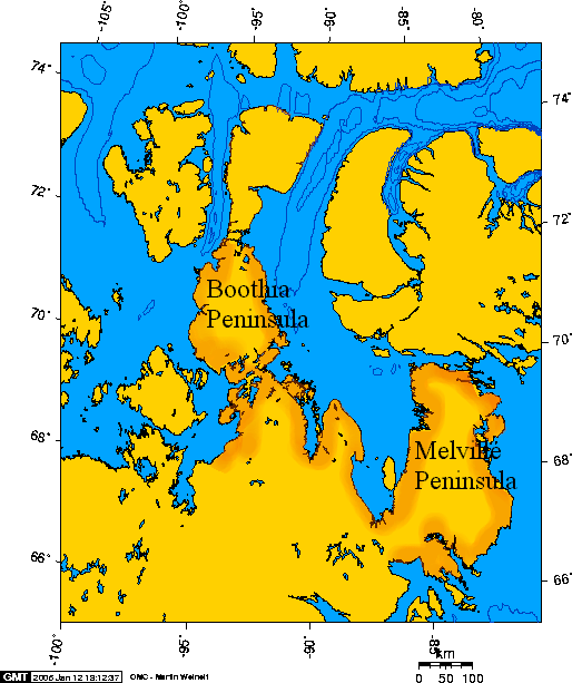
 Peninsulas de Boothia y Melville, Nunavut, Canada.
La Península de Melville es una gran península situada en el Ártico de Canadá. Desde 1999, administrativamente pertenece al territorio autónomo de Nunavut y antes, era parte del Distrito de Franklin.
Geografía
La península de Melville tiene una superficie de 65.000 km²[1] y está unida al continente americano por el Istmo de Rae, con una anchura de solo 65 km. Se adentra en el mar, en dirección casi SN, una longitud de unos 400 km y tiene una anchura máxima de 220 km. En su interior está el Lago Hall. Está limitada del siguiente modo: al sur, las aguas de Bahía Repulse y del Estrecho Frozen,[2] la separan de Isla Southampton; al este, por las aguas de Cuenca Foxe, situándose en la mitad de este tramo la Bahia Parry; al norte, por el Estrecho Fury y Hecla, que la separan de Isla Baffin; al oeste, por las aguas del Golfo de Boothia, encontrándose también mas o menos en su mitad la Bahía Garret y un poco más al sur Isla Wales.
Un puesto de la Compañía de la Bahía de Hudson se construyó aquí, en Bahía Repulse, en 1921.
Referencias
- Todo o parte de este artículo fue creado a partir de la traducción del artículo Melville Peninsula de la Wikipedia en inglés, bajo licencia Creative Commons Compartir Igual 3.0. y GFDL.
- ↑ http://encarta.msn.com/encyclopedia_761569537/melville_peninsula.html
- ↑ «Frozen Strait». The Columbia Gazetteer of North America (2000). Consultado el 2008-04-07.
Bibliografía
- Bolton, Thomas Elwood. Geology of Ordovician rocks, Melville Peninsula and region, southeastern district of Franklin. Ottawa: Energy, Mines and Resources Canada, 1977. ISBN 0-660-00822-X
- Dredge, Lynda A. 2000. "Age and Origin of Upland Block Fields on Melville Peninsula, Eastern Canadian Arctic". Geografiska Annaler Series A: Physical Geography. 82, no. 4: 443-454.
- Dredge, L. A. Quaternary Geology of Southern Melville Peninsula, Nunavut Surface Deposits, Glacial History, Environmental Geology, and Till Geochemistry. Ottawa: Geological Survey of Canada, 2002. ISBN 0-660-18619-5
- Frisch, T. Precambrian Geology of the Prince Albert Hills, Western Melville Peninsula, Northwest Territories. Ottawa, Canada: Geological Survey of Canada, 1982. ISBN 0-660-10881-X
- Henderson, J. R. Structure and Metamorphism of the Aphebian Penrhyn Group and Its Archean Basement Complex in the Lyon Inlet Area, Melville Peninsula, District of Franklin. Ottawa, Ont., Canada: Geological Survey of Canada, 1983. ISBN 0-660-11485-2
- Mathiassen, Therkel, and Peter Freuchen. Contributions to the Geography of Baffin Land and Melville Peninsula. Copenhagen: Gyldendalske Boghandel, 1933.
- Schau, Mikkel. Geology of the Archean Prince Albert Group in the Richards Bay Area, Northeastern Melville Peninsula, District of Franklin, Northwest Territories. Ottawa: Geological Survey of Canada, 1997. ISBN 0-660-16086-2
Categorías: Penínsulas de Canadá | Geografía de Nunavut
Wikimedia foundation. 2010.