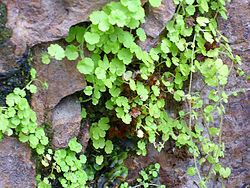
Sibthorpĭa — (S. L.), nach Sibthorp 1) benannte Pflanzengattung aus der Familie Scrophularineae Veroniceae, 14. Kl. 2. Ordn. L.; Art: S. europaea, kriechende Sumpfpflanze in England u. Portugal … Pierer's Universal-Lexikon
Plantaginaceae — Wegerichgewächse Ehrenpreis (Veronica officinalis und Veronica latifolia) Systematik Abteilung … Deutsch Wikipedia
Wegerichgewächse — Ehrenpreis (Veronica officinalis und Veronica latifolia) Systematik Eudikotyledonen … Deutsch Wikipedia
Plantaginaceae — Taxobox name = Plantain family image width = 225px image caption = Plantago major regnum = Plantae divisio = Magnoliophyta classis = Magnoliopsida ordo = Lamiales familia = Plantaginaceae familia authority = Juss. subdivision ranks = Genera… … Wikipedia
Plantaginaceae — Plantaginaceae … Wikipédia en Français
Aire Point to Carrick Du SSSI — is a Site of Special Scientific Interest on the Penwith Peninsula, Cornwall. It is 5.98 square kilometres in extent, stretching from gbmapping|SW360279 to gbmapping|SW513410. The site is designated both for its biological and its geological… … Wikipedia
Exmoor Coastal Heaths — Infobox SSSI name=Exmoor Coastal Heaths aos=Somerset Devon interest=Biological gridref=gbmappingsmall|SS620480 area=1758.3 hectare (4344.7 acre) notifydate=1994 http://www.natureonthemap.org.uk/map.aspx? ] Exmoor Coastal Heaths… … Wikipedia
Roebuck Meadows — Infobox SSSI name=Roebuck Meadows aos=Somerset interest=Biological gridref=gbmappingsmall|ST132354 area=3.6 hectare (8.9 acre) notifydate=1988 http://www.natureonthemap.org.uk/map.aspx? ] Roebuck Meadows (gbmapping|ST132354) is a 3.6 hectare (8.9 … Wikipedia
Crowcombe — Coordinates: 51°07′26″N 3°13′38″W / 51.1240°N 3.2273°W / 51.1240; 3.2273 … Wikipedia
Flora and fauna of Cornwall — Some of the plants in Trebah garden West and south Cornwall is known fo … Wikipedia
 Sibthorpia