Churachandpur

Churachandpur
Churachandpur
Localidad de la India
Churachandpur
Churachandpur
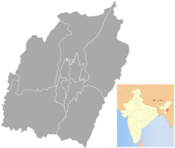
Ubicación de Churachandpur en Manipur.
24°20′43″N 93°41′59″E / 24.34528, 93.69972Coordenadas: 24°20′43″N 93°41′59″E / 24.34528, 93.69972
Entidad Localidad
 • País Bandera de India India
 • Estado Manipur
 • Distrito Churachandpur
Altitud  
 • Media 829 msnm
Población (Est.2010[1] )  
 • Total 2.340 hab.
Huso horario IST UTC +5:30
PIN[2] 795128
Código de área 3874

Churachandpur es una localidad de la India, centro administrativo del distrito de Churachandpur,en el estado de Manipur.

Contenido

Geografía

Se encuentra a una altitud de 829 msnm a 68 km de la capital estatal, Imfal, en la zona horaria UTC +5:30.

Demografía

Según estimación 2010 contaba con una población de 2 340 habitantes.[1]

Referencias

Enlaces externos


Wikimedia foundation. 2010.

Игры ⚽ Нужен реферат?

Mira otros diccionarios:

  • Churachandpur — This article is about the municipality in Manipur, India. For its namesake district, see Churachandpur district. Lamka   town   Coordinates Country India …   Wikipedia

  • Churachandpur — Original name in latin Churchndpur Name in other language Churachandpur, Churchndpur State code IN Continent/City Asia/Kolkata longitude 24.33353 latitude 93.66999 altitude 944 Population 47774 Date 2012 10 06 …   Cities with a population over 1000 database

  • Churachandpur district — This article is about the district. For its eponymous headquarters, see Churachandpur. Churachandpur   district   …   Wikipedia

  • Manipur — মণিপুর   State   Seal …   Wikipedia

  • Zou people (India) — The Zou as a Minority Community= The Zou/Zo tribe is a less well known indigenous community living along Indo Burma frontier. In India, Zous/Zos are officially recognized as one of the 29 Scheduled Tribes within the state of Manipur (See List of… …   Wikipedia

  • Tipaimukh Road — is a National Highway in Manipur, India, designated NH 150. National Highway 150 The Central Government of India declared Tipaimukh Road, a State Highway in Manipur, a National Highway (NH 150) on January 6, 1999. The total length of this highway …   Wikipedia

  • Manipur University — Established June 5, 1980 Type Public Vice Chancellor Prof H Nandakumar [1] …   Wikipedia

  • Hiangzou — Infobox Indian Jurisdiction native name=Hiangzou | type = town| latd = 24.3|longd=93.15 locator position=left| state name=Manipur district = Churachandpur altitude=914.4 population as of=2001 population total=| Hiangzou is a new ward within… …   Wikipedia

  • Zomi — is the name of an ethnic group of people that occupy Northwest Burma, Northeast India, and Northeast Bangladesh, and normally known as Lushai, Chin and Kuki to the outsiders. However, a single name Chin or Lushai or Kuki has technical limitation… …   Wikipedia

  • Chandel district — This article is about the district. For its eponymous headquarters, see Chandel, India. Chandel   district   …   Wikipedia

Compartir el artículo y extractos

Link directo
Do a right-click on the link above
and select “Copy Link”