Gnosall

Gnosall
Gnosall
Parroquia civil y pueblo del Reino Unido
Farmland looking Towards St. Lawrence Church - geograph.org.uk - 375984.jpg
Vista de Gnosall.
Gnosall
Gnosall
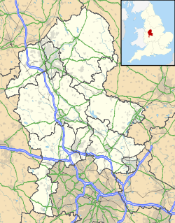
Ubicación de Gnosall en Staffordshire.
52°47′8.1″N 2°15′17.4″O / 52.785583, -2.254833Coordenadas: 52°47′8.1″N 2°15′17.4″O / 52.785583, -2.254833
Entidad Parroquia civil y pueblo
 • País Bandera del Reino Unido Reino Unido
 • Nación constitutiva Inglaterra
 • Región Midlands del Oeste
 • Condado Staffordshire
 • Distrito Stafford
Superficie  
 • Total 37,77 km²
Población (2001)  
 • Total 4.877 hab.
 • Densidad 129,12 hab/km²
Huso horario GMT (UTC0)
 • en verano BST (UTC +1)
Código postal ST20
Prefijo telefónico 01785

Gnosall es una parroquia civil y un pueblo del distrito de Stafford, en el condado de Staffordshire (Inglaterra).

Contenido

Geografía

Según la Oficina Nacional de Estadística británica, Gnosall tiene una superficie de 37,77 km².[1]

Demografía

Según el censo de 2001, Gnosall tenía 4877 habitantes (49,83% varones, 50,17% mujeres) y una densidad de población de 129,12 hab/km². El 19,77% eran menores de 16 años, el 73,06% tenían entre 16 y 74, y el 7,18% eran mayores de 74. La media de edad era de 40,42 años. Del total de habitantes con 16 o más años, el 21,08% estaban solteros, el 64,99% casados, y el 13,93% divorciados o viudos.[2]

Según su grupo étnico, el 99,38% de los habitantes eran blancos, el 0,29% mestizos, el 0,21% asiáticos, el 0,06% negros, y el 0,06% de cualquier otro salvo chinos. La mayor parte (97,4%) eran originarios del Reino Unido. El resto de países europeos englobaban al 1,13% de la población, mientras que el 1,48% había nacido en cualquier otro lugar. El cristianismo era profesado por el 82,53%, el budismo por el 0,08%, el hinduismo por el 0,18%, el judaísmo por el 0,06%, el islam por el 0,21%, y cualquier otra religión, salvo el sijismo, por el 0,12%. El 10,7% no eran religiosos y el 6,11% no marcaron ninguna opción en el censo.[1]

Había 1975 hogares con residentes, 50 vacíos, y 3 eran alojamientos vacacionales o segundas residencias.[2]

Referencias

  1. a b Tablas: «Usual Resident Population (KS01) for Amalgamated Parishes», «Ethnic Group (KS06) for Amalgamated Parishes», «Country of Birth (KS05) for Amalgamated Parishes» y «Religion (KS07) for Amalgamated Parishes», disponibles para descarga aquí. Office for National Statistics (inglés).
  2. a b «Area: Gnosall CP (Parish)» (en inglés). Office for National Statistics. Consultado el 13 de octubre de 2011.

Enlaces externos


Wikimedia foundation. 2010.

Игры ⚽ Поможем решить контрольную работу

Mira otros diccionarios:

  • Gnosall — is a large village in the Borough of Stafford, Staffordshire, England, with a population of approximately 5,000. It lies on the A518, approximately half way between the towns of Newport (in Shropshire) and the county town of Staffordshire,… …   Wikipedia

  • Gnosall — Original name in latin Gnosall Name in other language Gnosall, Gnossall State code GB Continent/City Europe/London longitude 52.78558 latitude 2.25483 altitude 102 Population 4171 Date 2011 03 03 …   Cities with a population over 1000 database

  • Gnosall Rural District — infobox historic subdivision Name= Gnosall HQ= Status= Rural district Start= 1894 End= 1934 Replace= Stafford Rural District Cannock Rural District PopulationFirst= 4,697 PopulationFirstYear= 1901 PopulationLast= 4,732 PopulationLastYear= 1931… …   Wikipedia

  • Moreton, Staffordshire — Moreton is a small rural village in Staffordshire, England. It lies 3.5 miles (5.6 km) south west from Gnosall railway station, and 4 miles (6.4 km) south east from Newport, both on the Stafford and Shrewsbury section of the former… …   Wikipedia

  • Newport, Shropshire — This article is about Newport in Shropshire. For other uses, see Newport (disambiguation). Coordinates: 52°46′09″N 2°22′43″W / 52.7691°N 2.3787°W …   Wikipedia

  • Adam Blakeman — Rev. Adam Blakeman was born in Gnosall, Staffordshire, England, June 10 1596. His birthplace is frequently misspelled in websites due to transcription errors from old records.Blakeman matriculated (entered college) at Christ Church, Oxford, May… …   Wikipedia

  • Haughton, Staffordshire — Haughton is a village in Staffordshire, England, approximately 4 miles outside the county town of Stafford. It lies on the A518 between Stafford and Gnosall.A small and peaceful rural village, Haughton contains 2 public houses, The Shropshire and …   Wikipedia

  • Gosnold — The county of Stafford has some fascinating surnames, all of whom owe their origin to the Domesday Book of 1086 which first mentions Geneshale now known as Gnosall (village). The development of this name is in effect the development of the… …   Surnames reference

  • Shropshire Union Canal — The Shropshire Union Canal is a navigable canal in England; the Llangollen and Montgomery canals are the modern names of branches of the SU system and lie mostly in Wales.The canal lies in Staffordshire, Shropshire and Cheshire in the north west… …   Wikipedia

  • Stafford (borough) — Stafford is a local government district with borough status in Staffordshire in England. It is named after and includes the town of Stafford. It also includes the smaller town of Stone and numerous villages.The borough was formed on April 1, 1974 …   Wikipedia

Compartir el artículo y extractos

Link directo
Do a right-click on the link above
and select “Copy Link”